
NYC Comprehensive Waterfront Plan
The City’s draft waterfront plan calls new public access at Williamsburg Bridge Park (5) and the former BRT power plant site (6).
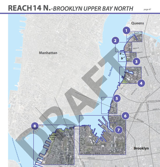
The Department of City Planning has released its draft comprehensive waterfront plan (aka Vision 2020), and it has a lot for North Brooklyn to get excited about (and quite a few things that reiterate past promises).
The plan identifies a number of areas for new waterfront access, including the Williamsburg Bridge Park site just south of Domino, which is currently occupied by two city agencies that are not providing waterfront-dependent services (“explore potential for open space under bridge dependent on finding relocation sites for current DOT and DCAS facilities”). The reuse of this site was first proposed a few years ago by then-Councilmember David Yassky, and it got some added traction during the Domino rezoning. (The Domino rezoning will result in a reduction of access to open space on a per capita basis; the creation of a large waterfront park right next door would reverse that.) Since the Domino rezoning, NAG and other local groups have been looking into how to jumpstart the conversion of this site into public park space.
The City’s waterfront plan also calls for an expansion of public access (visual and physical) to the Navy Yard’s waterfront, and for public waterfront access at the former BRT (Con Ed) power plant site at Division and Kent. Even more interesting is that the plan calls for this site to be industrial or commercial (“explore options for redevelopment for industrial and/ or commercial uses with opportunities for public access if appropriate”), rather than residential. Meaning that the site is envisioned more as an extension to the Navy Yard than as an extension to the South Williamsburg residential waterfront north of Division (the Kedem, Schaefer and Certified sites).

The plan also includes new ideas for Newtown Creek, including a boat launch at Manhattan Avenue. (And some old ideas
yet to be followed through on.)
The plan also has some new ideas for Newtown Creek, which largely boils down to public access and residential/commercial uses at the mouth of the creek and continued industrial uses with public access (like the NCWWTP nature walk) further upstream. The plan calls for residential and commercial development of the Long Island City waterfront (with public access to the creek), opposite Manhattan Avenue, as well as improvements to public access and a boat launch at the Manhattan Avenue street-end. (The boat launch could be referring to the proposed Greenpoint Boathouse at GMDC’s Manhattan Avenue facility – if it isn’t, it should be.) There are also rather fuzzy calls for public access of some sort beneath the Greenpoint Avenue and Kosciusko Bridges.
It should be noted that the plan also reiterates a number of past promises that the City has made to Greenpoint and Williamsburg – promises that are nice to see reiterated, but would better appreciated if implemented. These include the development of 65 Commercial Street as a park, the development of the Greenpoint Lumber for residential use, the redevelopment of the India and Java Street piers and the acquisition and build-out of Bushwick Inlet Park. All of these are promises that the City made as part of the 2005 rezoning that remain unfulfilled (the India/Java Piers have recently taken on a controversy of their own).
In all, though, there are a lot of new and very positive ideas being put forth in the City’s plan. The plan, which is part of a decennial review of the waterfront that City Planning is required to undertake, will be reviewed at a public hearing on October 12, after which it will be issued as official City policy.
via Brownstoner