Hurricane Irene
The exact track of Hurricane Irene is still a big unknown, but it sure is looking likely that it will dump a lot of wind and water on NYC come Sunday or Monday (or both). The latest tracking (taken with a big grain of salt) even have the eye of the storm going along the Queens/Nassau border.

Source: NYC Office of Emergency Management
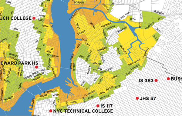
So it seems like a good time to dust off this map and remind people in North Brooklyn that a lot of us live in flood-prone areas (you can download the full map here). The areas in orange “face the highest risk of flooding from a hurricane’s storm surge”, and include all low-lying coastal areas. The areas in yellow (which includes just about all of Greenpoint, the industrial areas of East Williamsburg, and parts of South Williamsburg) “may experience storm surge flooding from a MODERATE (Category 2 and higher) hurricane”. Areas in green (mostly on the Northside and just in on the Williamsburg waterfront) “may experience storm surge flooding from a MAJOR (Category 3 & 4) hurricane” making a more or less direct hit on the NYC (“unlikely” according to the City). The areas in white (the Southside and East Williamsburg residential areas) are unlikely to see any storm surge flooding.
You can find exactly which zone you are in – and where the nearest evacuation center is – here, and you can find the City’s Hurricane Guide here.

So if I live at N 6th and Driggs, what can I expect? I’ve looked through the sites and maps but I’m still not sure how to gauge this.. will my apartment be impacted and to what degree?
North 6th and Driggs is green, so lowest level of danger (but not completely out of danger). It would have to be a really, really catastrophic hit, but you could see flooding.
NYC.gov has a ton of information – I suggest that anyone go there, read up, and as the Mayor says, be prepared for the worst (but hope for the best!).
FWIW, I live in green too.