
A Creek Runs Through It
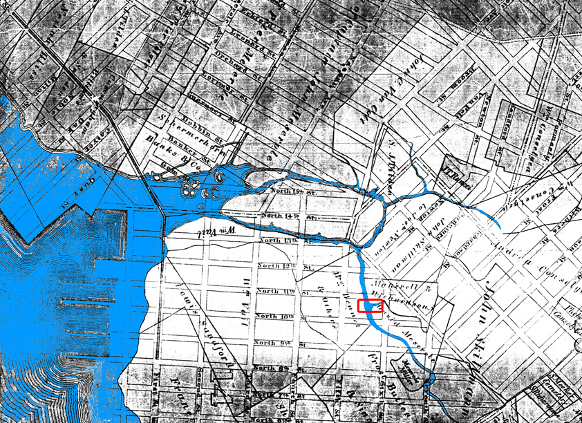
Gowanus Lounge has been all over the Roebling Oil field of late1. One thing that intrigued me about the appearance of (purported) toxins ickiness at this site and across the street at the apartment building on the northwest corner or Roebling and North 11th2 was the fact that neither site appeared to have been home to the usual toxic soup of Williamsburg’s past. In fact, both sites seem to have housed pretty benign uses, as the 1929 map below shows.

Map 1: Hyde insurance map, 1929 (NYPL).
So why the oil here? And what of Rob’s contention that the blocks to the southeast might be next? Turns out, he could be on to something; I was just looking at the wrong map.
Once upon a time, Williamsburg and Greenpoint were divided by a rather large creek and surrounding marshland – as seen below in an 1833 map of the Village of Williamsburgh. The creek was originally called Norman Kill, after one Dirck de Noorman, or Dirk the Norseman – the first European settler in this part of Brooklyn. Later renamed Bushwick Creek, this waterway was at one point navigable by boat as far inland as Grand and Rodney. Older maps show much of the area to the east of Union Avenue and throughout McCarren Park as marshes.3 As late as the 1830s, the only direct connection between Williamsburgh and Greenpoint at the waterfront was a long footbridge (seen below) connecting First Street (Kent Avenue) to Franklin Street. It was only in 1838 was a vehicular bridge constructed across Bushwick Creek. Prior to that, Greenpointers who didn’t want to travel far inland had to use boats to travel to Williamsburgh.
Map 2: Base map: Village of Williamsburgh, Kings County, 1833 (from Brooklyn Genealogy).
Bushwick Creek and the original East River shoreline are shown beneath the street grid.
Illustration: Brooklyn11211
Today, the little that’s left of Norman Kill is known as Bushwick inlet (see map #3, below). It is still the dividing line between Greenpoint and Williamsburg, its just not the barrier it once was.
So what does all this ancient history have to do with the discovery of oil on Roebling Street? Maybe nothing, but maybe this: a branch of Norman Kill runs directly beneath the Roebling Oil field site (outlined in red on maps #2 and #3). It also runs beneath the newish apartment building across North 11th Street to the north4, and beneath the block to the southeast that GL identified as another possible oil field site. This tributary, once known as Swede’s Kill, is the part of Bushwick Creek that was navigable as far south as Grand and Rodney Streets.5
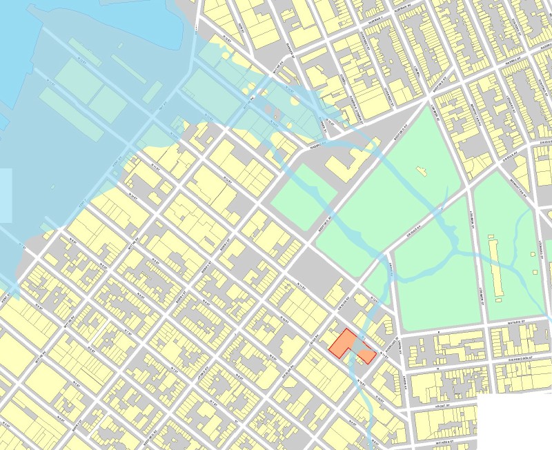
Williamsburg, 2007, with old waterways overlaid (base map from DOITT viaCITI).
With all the publicity over the Exxon (really Mobil/Standard Oil) spill in Greenpoint, its tempting to wonder if that is the source of the Roebling Oil field. But the Greenpoint oil spill is centered on Newtown Creek in the far northern section of Greenpoint, where Standard Oil (later Mobil, now ExxonMobil) had a large oil storage facility.
But Standard Oil had other operations in Williamsburgh and Greenpoint (Standard wasn’t a monopoly for nothing). Chief among these – and perhaps most significantly for the discussion at hand – was Charles Pratt’s Astral Oil refinery, which was located at the mouth of the Bushwick Inlet. Today, this is the Bayside Oil site – a site that is slated to become a public park, but which Parks has acknowledged is an environmental nightmare (understandable, considering that the site has been home to some form or another of petroleum processing for close to 150 years).
And, yes, if you look at maps #2 and #3, you will see that the Bayside/Astral site is right downstream from the Roebling Oil field.
But wait – oil can’t flow upstream, can it? Well, just as the East River is not a river (to us in Brooklyn, its not even East). The East River is a tidal strait – water flows in and out from New York Bay and Long Island Sound (and to some extent the Harlem “River”) based on the tides. I suspect that this tidal action was what formed Norman Kill, and could still be affecting the flow of water beneath parts of Williamsburg. I’m no hydrologist, but clearly there was once a network of waterways that to one extent or another could still exist beneath the streets. And that network of waterways could be pushing oil and other ickiness below the former marshlands of north Williamsburg.
If the old creek system is in some way responsible for the appearance of oil at the Roebling/North 11th site, the Bayside/Astral would certainly not be the only potential source for oil itself. There were many other potential sources of historic oiliness, including the Williamsburgh Gas Light Company, which was located west of Kent Avenue between North 11th and North 12th Streets, and a Brooklyn Union Gas facility on Berry between North 12th and North 13th (seen on map #1, above).
So perhaps it is geography that has reared its ugly head on Roebling and North 11th.
1. UPDATE: I see that the NY Times has picked up the story in a small item in today’s City section (in typical fashion, the Times cites “bloggers”, without giving any direct credit to GL, who has done a ton of work on this story over the past months). The article does not add much to the identification of the source of the oil at the Roebling Oil Field, but a geologist is quoted as saying that there might be a contamination source north or northeast of the site. This would be consistent Bushwick Creek hypothesis outlined here.[back]
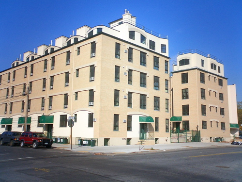
2. Quite possibly, the ugliest building in Williamsburg.[back]
3. Perhaps this was why much of southern Greenpoint in the area around Banker Street remained undeveloped into the early 20th century.[back]
5. Jan de Swede was an early settler of Williamsburgh (then known as Bushwick), who built his house at the head of Swede’s Kill, at what today is the intersection of Grand and Rodney.[back]
Bravo! This is the coolest bit of investigation and theorizing we’ve seen in a while. Looking forward to checking out the rest of your blog.
Can you link to a higher-res version of the 2007 map? The old shoreline is fascinating, but we can’t make out the street names. The shoreline in the overlay probably represents the high-tide line?
Thanks – I will reset the link with a higher res map (actually, it will just be physically larger, so should be readable).
I don’t know if the 1833 map that was source showed high tide or mean tide. Because I had to distort the map to get it to fit the current map, take the shoreline here with a grain of salt. The relationship of the creek to the North 11th site was what I was controlling for. (The 1833 map itself shows all of the streets too.)
Starting this Monday we will be showing our documentary which focuses a lot on the Greenpoint Oil Spill on vbs.tv
http://www.myspace.com/thetoxicapple
Could this be why when they were pile driving at 20 Bayard street they hit the water table at 10 or 12 feet?
You betcha.
Another tidbit is that 20 Bayard’s piles aren’t on bedrock (at all supposedly). They went down 100 feet and gave up , and just started building. The Developers Group quickly divested itself of any interest in the property, early on.
It’ll have funhouse doors and windows before too long (if it doesn’t fall down)
You really think that’s the ugliest building in Williamsburg? This is actually one of just a few that I think are pretty OK. The Mission-style one next door is better, though. Hmm.
The North 11th building is pretty atrocious, imo – sort of looks like they used leftover parts from a chain motel. Though by Williamsburg standards its pretty old (the picture I linked to was 2004, and the building had already been up a few years). Its since been eclipsed by many other atrocities.
What is the “mission” style building?
Haifa Holiday Inn
Dirck the Noorman lives!
The G train runs right under Union Ave and cuts under McCarren Park. If there’s that much oil underground wouldn’t it have been a big problem in the construction of that section of subway? The train is at least as far underground as the basement at Roebling and N11th and less than 80 feet away…
Interesting point. That section of the G line was constructed fairly recently (mid-1930s), and I can find no reference to problems during construction. OTOH, the run below Union is a block away from this portion of the Norman Kill, so its quite possible that there was no interaction here. Further north, in McCarren, the subway and the creek would have crossed paths.
In one of the Armbruster books, the author mentions that the Bushwick Creek had turned into a foul dumping ground that could barely even be called a waterway. It was such a health hazard that it was filled in by the city (brooklyn or new york, not sure of the date) and Greenpoint Park (now McCarren park) was created on part of the swamp land. God only knows what kind of biological and chemical sludge is under there.
Armbruster, Eugene L. (1912). The Eastern District of Brooklyn. Brooklyn.
Armbruster, Eugene L. (1942). Brooklyn’s Eastern District. Brooklyn.
Check out the quotes about the oil refineries at the Bushwick Creek from “THE CONDITION OF BROOKLYN’S STREETS AND HOUSES”, Brooklyn Daily Eagle, 9 May 1885. Transcript can be found at
http://www.bklyn-genealogy-info.com/Town/Streets/1885.Streets.html
” The oil refineries are complained of
as a nuisance on account of the smell emitted by them, but no one pretends
or claims that the smell makes them sick. It is simply very unpleasant. The
oil refineries have another bad quality, also. The have flooded Bushwick and
Newtown Creeks with oil so that a match would set them blazing and all
houses in the vicinity of the creeks and the oil refineries stand in constant
danger of conflagration.”
…
“But Newtown and Bushwick creeks are nuisances themselves. The are
indescribably filthy, and they ooze through their slimy beds, not bearing the
sewage thrown into them away to the East River, but carrying it slowly about
till low tide comes and gives them a chance to deposit it in any of the swamps
which constitute their banks.
An old general law stands in the way of an improvement of Bushwick Creek,
such as would be made if it were gradually filled in at the southern end. It was
navigable and is protected from interference by law made to protect navigable
rivers. Now that the stream is no longer navigable, even for a rowboat, the
result of the law is ridiculous.”
I NOTICED NORTH 12TH ST. AND KENT AVE IS MENTION RE: OIL SPILL .
COULD U SEND NE MORE INFO RE; NORTH 12TH STREET , OIL SPILL (FLOW)
THANK YOU
dear sir or madam:
where could i find this information re: oil spill
that runs underground re: north 11th street & 12th street (kent ave)in williamsburg brookyn ny 11211.
thank you mike