Thoughts on River Ring
River Ring – the proposed rezoning by Two Trees of the former Con Ed site at Metropolitan and River Street – kicks off its ULURP review with a Community Board 1 Land Use committee meeting on Wednesday. Hopefully the CB recommends for changes but does not follow the lead of those who want to kill the project outright. This is a chance to rezone one of the last waterfront parcels on the East River, locking in a significant open space connector, affordable housing and more.
First off, this site should be residential. Period.

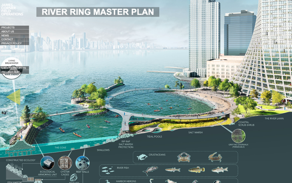
River Ring Master Plan
via FieldOps
There is no valid public policy reason to leave this zoned for heavy manufacturing. It should be smaller (floor area), which will make it shorter (not a big deal for me, but everyone else keys on the height). The open space is visionary and should be a model for future waterfront development – every developer should be held to this standard. It has everything community activists have been clamoring for and will connect the Southside waterfront and the rest of the neighborhood. There should be more affordable housing and it should be more affordable. 30% to 35% of the units, at a project-wide average AMI of 40%.
Hopefully CB1 supports the residential zoning *with* conditions. As they did for the 2010 Domino Rezoning (pre-Two Trees). In 2010 the CB did not say that residential use was inappropriate at Domino – rather that developer was trying to supersize the density. They should say the same thing here – support residential use, affordable housing and open space, but see it done better. (This would also be consistent with CB1’s District Needs statement, which lists affordable housing as the top TWO (of three) key issues for the community. It would also be in line with CB1 recommendations on other waterfront projects – Kedem Winery (420 Kent), Certified Lumber (Rose Plaza) and Shaefer Landing. Saying that this one parcel should be kept as M3 zoning doesn’t make sense in light of all these prior recommendations.)
There really is no valid public policy reason to leave the former Con Ed property zoned for M3 (heavy manufacturing). What kind of residential and how much can be debated, but if you are arguing to leave this as manufacturing you are not engaging in an honest debate. (The only other valid use I could see here is a public park. That would cost upwards of $300M for acquisition and construction – given the City’s track record at Bushwick Inlet, I’m not holding my breath. Not to mention that Parks would never build a build a waterfront park to the level of quality and design that Two Trees is proposing.)
This site should have been rezoned for residential years ago. In 2005 Domino was still in operation and it made sense to leave the area from Bway to N3 as manufacturing. But Domino closed shop just as that rezoning was going through, making the M zoning has been an anachronism. 11 years ago, when the first Domino Rezoning came through CB1, I asked why the City wasn’t developing a plan for the whole area – I still think that they should have. But instead, these parcels have been rezoned piecemeal – zoning, not planning, once again is the norm in NYC.
How much residential? I do think that the density being proposed is too much. Not a lot too much, but a bit too much. Back of the envelope, maybe 10% too much – the zoning should be straight R8, 6.5 FAR with the inclusionary bonus, same as the rest of the waterfront towers. (Yes, the waterfront sites from the 2005 Greenpoint-Williamsburg waterfront rezoning have a blended R6/R8 zoning, but on zoning lots that are 2 to 3 times the size of River St. and go all the way out to Kent/West. Blended zoning here would kill the affordable cross subsidy.)
Two Trees is also seeking a zoning waiver to reduce parking below what is required by zoning. Grant it. More parking means more cars, there is solid documentation for this. And more parking also means less affordable housing, there is solid documentation for that too.
In terms of the overall proposal, I love the waterfront access and open space. Field Ops design is truly transformative and is pretty much everything that open space advocates in the community have been asking for for years. It is resilient, both diurnally and annually. It is the first truly resilient open space on 4 miles of waterfront. It brings the public to the water without bulkheads, wharves or “get-downs”. It avoids the use of rip-rap and other unfriendly barriers between people and the water. The design reuses the pod wharves from the Con Ed site in creative ways to deal with the tides and currents of the East River. Most importantly, it CONNECTS the waterfront – the Northside esplanades to Grand Ferry Park, something that I and others have been advocating for years now. And it does so in a way that is a thousand times better than the waterfront esplanades of the 2005 rezoning. (Like at Domino, Two Trees promises to maintain the park rather than turning it over to Parks Department to manage – that is a very good thing too.)
(Also worth noting here for the proponents of leaving the M3 zoning intact – there is no requirement to provide waterfront access under the existing zoning – this property falls outside the Waterfront Access Plan, which requires public access to the waterfront. If an as-of-right development were to provide any waterfront access (and they don’t have to), it could be 100% private. No public access, not even an esplanade.)
As for the architecture, OK, meh. For me, BIG’s whole schtick is about, well, big ideas with no nuance. The massing here is fine – yeah, the towers are ginormous, but any reduction in FAR will quickly knock off a lot of those small floor plates. Cut back the FAR 10% and I bet the height drops by 25% or more. I‘ve never been an opponent of height on its own. Everything on the waterfront is out of context with the neighborhood, but the overall urban design here is so much better than the 2005 paradigm.
The buildings from the 2005 rezoning – 40 stories with large floor plates on blocks that 400’ deep to the river set in semi-private compounds – are more offensive in terms of urban design than what is proposed here. Take a walk down South 1st from Kent and compare that to a walk down North 5th from Kent. The Battery Park City model on which the 2005 rezoning was based is just not good urban design, especially on very deep blocks, and 1 South 1st is great proof that taller buildings on smaller floorplates are more pedestrian friendly.
On affordable housing, there should be more. 30% to 35% at an overall average 40% AMI. Maybe this is unrealistic with existing subsidies & inclusionary housing, but if the city, state and feds aren’t going to build affordable housing they should at least pay others to do so. (Keeping this site zoned M3 means no affordable housing at all. 200+ units won’t be built under an M3 (or M-anything) scenario.)
And please, change the name.
