“The Greenpoint” Developer Offers India Street Elevated Walkway for Flooded Ferry Entrance

What happens if you rezone a neighborhood for thousands of new residents, but don’t bother to plan any infrastructure around it?

As I understand it, India Street’s catch basins don’t tie into the City’s sewer system, they never have. And the City doesn’t have plans for these hookups for a number of years out. So people who wanted to get to the India Street Pier (and the ferry) were facing years of having to parkour over the plastic barriers to get to the pier. But now the developer of the “The Greenpoint” condominium is addressing the access to India Street via a temporary raised sidewalk while (as they should, even though the lack of infrastructure isn’t their doing this is literally their front yard).
Post-Sandy Rezoning at CB1

The agenda for Community Board 1’s Land Use Committee meeting tonight is a pretty sleepy affair – two BSA applications, both of which are retreads that the Board has heard in years past. However, there is one very important agenda item, which is a presentation by City Planning on the City’s proposed Flood Resilience Zoning Text Amendment, which modifies the zoning to allow new development to meet the new flood zone requirements.

I saw the presentation last week at CB2, and what the city is proposing is to modify the zoning to allow flood-resilient design with no (or minimal) impact on development rights. For those of you hoping that Sandy and the new FEMA flood zones will make development in Zone A impossible, this makes development possible. Actually, post-Sandy regulations don’t make development in Zone A impossible in the first place, in simple terms, they only restrict development and use at the base of buildings. These changes to the zoning will, in some case, permit taller development to compensate for the fact that ground floors now need to be flood-proofed in some manner and will no longer be usable floor area. Other modifications include not counting construction below the flood level as floor area and allowing greater amounts of rooftop mechanical area.

When: Tonight (June 25), 6:30 pm
Where: CB1 offices, 435 Graham Avenue

Hurricane Irene

The exact track of Hurricane Irene is still a big unknown, but it sure is looking likely that it will dump a lot of wind and water on NYC come Sunday or Monday (or both). The latest tracking (taken with a big grain of salt) even have the eye of the storm going along the Queens/Nassau border.

irene-map.png

Source: NYC Office of Emergency Management

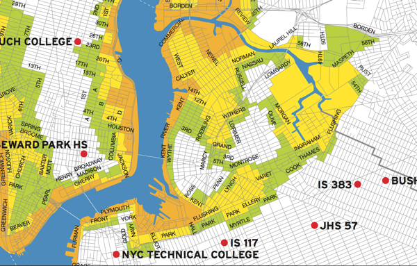
So it seems like a good time to dust off this map and remind people in North Brooklyn that a lot of us live in flood-prone areas (you can download the full map here). The areas in orange “face the highest risk of flooding from a hurricane’s storm surge”, and include all low-lying coastal areas. The areas in yellow (which includes just about all of Greenpoint, the industrial areas of East Williamsburg, and parts of South Williamsburg) “may experience storm surge flooding from a MODERATE (Category 2 and higher) hurricane”. Areas in green (mostly on the Northside and just in on the Williamsburg waterfront) “may experience storm surge flooding from a MAJOR (Category 3 & 4) hurricane” making a more or less direct hit on the NYC (“unlikely” according to the City). The areas in white (the Southside and East Williamsburg residential areas) are unlikely to see any storm surge flooding.

You can find exactly which zone you are in – and where the nearest evacuation center is – here, and you can find the City’s Hurricane Guide here.