
Aaron Short covers the City’s abandonment of Bushwick Inlet Park.
City Too Poor to Build Promised Bushwick Inlet Park
Reversal on Plans for Williamsburg Park
The Daily News reports today that the City is reneging on one of the key components of the 2005 Greenpoint/Williamsburg rezoning – the 28-acre Bushwick Inlet Park. The park – which would straddle Greenpoint and Williamsburg – was the centerpiece of the City’s open space plan under the rezoning.
In the six years since the rezoning, the City has acquired less than a third of the property that was to make up the park. In a letter to one of the property owners on the site, the Parks Department is now saying that it has “no schedule for the acquisition of the site” (a position which was apparently reiterated by other City officials in a meeting with the Community Advisory Board last week).
In the 2005 rezoning, the City promised that it would add roughly 38 acres to North Brooklyn. Six years – and thousands of new housing units – later, less than 3 acres of that is actual, usable open space. The rest is 35 acres of broken promises and, ultimately, a ruined rezoning.
Bushwick Inlet Park Update
Bushwick Inlet Park – Someday.
Curbed has a post today headlined “Long-Delayed Bushwick Inlet Park Now Planning for 2012“. What they mean is that the big pile of dirt on Kent Avenue between North 9th and North 10th Streets will become the headquarters for North Brooklyn’s Parks operations will open in “winter 2012”.
Curbed mistakenly says that the “original plan, when the first phase of park construction kicked off back in 2009 after several delays, was for the whole 28-acre project to be done this summer”. Actually, the plan was only to have this little building completed by this summer. But even that is not going to happen.
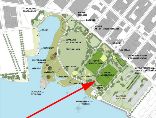
So this seems like a good time to check in on the status of Bushwick Inlet “Park”. You might remember that it was the major open space concession in the 2005 rezoning of Greenpoint and Williamsburg – a 28-acre waterfront park for two neighborhoods that historically ranked near the bottom in terms of open space. Bushwick Inlet Park represents over three-quarters of the new park space promised under the 2005 rezoning. That rezoning passed six years ago this month. Hundreds of new apartments have been constructed on the waterfront at the Edge and Northside Piers. Thousands of new apartments have been constructed on sites inland from the waterfront.
So how is this jewel of the North Brooklyn waterfront coming along?
We have a soccer field. It’s a very nice soccer field, but it is not a 28-acre soccer field.
There is a big pile of dirt where the Parks headquarters will someday be, and that project is actively under construction. Of course that headquarters was supposed to “be” this summer. Instead, it is now “on schedule” for completion in winter 2012. In other words, it is about a year and a half behind schedule.
Someday, that soccer field will look out on a waterfront esplanade, a restaurant and a pier-like structure. But right now it looks out on a chain link fence, and the esplanade is but a promise.
That’s the parcel between North 9th and North 10th Streets, which accounts for about 15% (4.1 acres) of the promised park.
There is less progress on the other 24 acres. To start with, the City doesn’t own most of that land – all they’ve managed to acquire is the 1.9-acre former Sanitation lot on Kent between North 11th and North 12th. The CitiStorage site (6.8 acres between North 10th and North 12th), the Bayside Fuel Oil site (7.3 acres between North 12th and North 14th) and the Motiva site (2.4 acres along Quay Street) are still privately owned.* Even if they were acquired today, it would take the City many years and many millions of dollars to clean them up and turn them into a park.
Yes, times are tough and the budgets are tight. But the 2005 rezoning did come with an explicit promise – the private sector would build a lot of apartments, and the City would build some parks and open space. The private sector has kept up its end of the bargain – according to the US Census, about 2,200 people were added to the census tracts covered by the rezoning area between 2000 and 2010 (and many more units have come online in the last year). The City has not kept up its end of the bargain – having turned only 3.1 acres of Bushwick Inlet Park into actual, usable parkland.
*If you’re doing the math, all that only adds up to 22.5 acres. There is an additional 5.5 acres or so taken up by the streets between these various lots. Presumably they are City-owned, but they aren’t park either. The East River State Park, between North 7th and North 9th, is another 6 acres or so, but is not included in these numbers.
What’s Going on at 65 Commercial?
A few weeks ago, all of the powers that be in North Brooklyn seemed to be aligned behind a single vision – getting the MTA to live up to its commitment to get out of 65 Commercial Street. Now, any deal to turn 65 Commercial seems about to founder on the rocks.
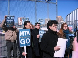
Photo: Queens Ledger
65 Commercial Street is the MTA property in north Greenpoint that was rezoned to parkland in 2005. As part of the agreement between the City Council and the Mayor’s office to allow the zoning to go forward, the Mayor’s office got the MTA to agree to give up the property in exchange for comparable land nearby.
For almost 6 years now, the MTA has been dragging its feet, claiming the land swaps offered by the City weren’t comparable and generally doing anything they could to not live up to their end of the bargain. Local politicians, especially David Yassky and Joe Lentol, pushed the City and the MTA to come to an agreement and turn this property as parkland. Steve Levin, who succeeded Yassky in 2010, took up the banner and kept the pressure on. Just last month, District Leader Lincoln Restler organized a protest at the site that drew renewed attention to the issue, and included the support of Congresswoman Nydia Velazquez.
Levin and the Mayor’s office, meanwhile, were pushing the MTA behind the scenes, and finally, in January, the MTA agreed to a series of swaps that would finally start the process of turning 65 Commercial into a park. The first swap was that the MTA would take about 42,000 square feet of former parkland under the Williamsburg Bridge, between Wythe and Berry, as the new location for their emergency response vehicles (ERVs). This aspect of the deal seems to have been in place for some time (I had heard about it going back at least a year, if not much longer). The sticking point all along was where to put the MTA’s 150 or so Access-a-Ride vehicles. Finally, in January, the City reached a deal for the MTA to take a block of property in Maspeth for these vehicles.
So now we have the structure of a deal in place, and all of the local pols on board – problem, solved, right?
No. It appears that the deal – and Greenpoint’s future park – is in jeopardy from two different directions.
First, at this week’s CB1 meeting, Velazquez staffer Evelyn Cruz announced that the Congresswoman is opposed to BOTH land swaps (both of which are to (and from) sites in her district, so these are issues that she should weigh in on). The Maspeth site for the Access-a-Ride vehicles is in an area that is zoned and used for heavy industry. The vehicles are already traveling through the district, and many will continue to travel through CB1 as well. So the distribution of burden there is shifting slightly, but all within an area that already has the burden. Yes, it would be ideal to get the vehicles out of our lives for good – less traffic, less pollution, less congestion for both Maspeth and Greenpoint – but shifting the burden a mile or so away, to an area that is zoned for such a use, seems reasonable given that where the vehicles are located today is zoned for parkland.
In other words, don’t throw out the good for the perfect. And focus on the real problem, which is where the second monkey wrench comes in.
This one is coming from the Mayor’s office, and it concerns the second land swap – putting the ERVs on a former playground site underneath the Williamsburg Bridge. If the City gets it way on this, it would basically screw over the Southside in favor of Greenpoint.
The Berry/Wythe site under the Williamsburg Bridge once held a playground, and it is still zoned for parkland. But the playground was closed in the early 1990s because paint stripping on the Williamsburg Bridge was covering the playground in lead-paint chips. At the time, the City agreed that the park would be reopened after reconstruction on the bridge was complete.
Here’s the thing – that piece of property is a horrible place for a playground. It is directly under the bridge, upland from the water. If it gets more than an hour of sunlight a day, I’d be amazed. What would make a great park is the DOT/DCAS site two blocks to the west – what I’ve taken to calling Williamsburg Bridge Park. Yes, part of it is under the bridge too, but all of it is on the water. And all of it extends down to Broadway, so eventually, there could be a waterfront esplanade running from Broadway to Grand Street. If Parks doesn’t like open space under a bridge, that area could be used for recreational structures or community facilities. But all of it should be publicly accessible.1
Instead of a substandard park inland, the Southside could get real waterfront access, a larger waterfront esplanade and substantially more open space. For a neighborhood that has one of the worst ratios of per capita open space (a ratio that will drop when Domino gets built), this would be a huge step forward.
Because the Berry/Wythe site is mapped as parkland, the City can’t just take it away – under State law, it has to provide comparable new parkland to offset the loss of this parkland. As I noted above, swapping Berry/Wythe for the DCAS/DOT site would to just that – and more. The neighborhood – the immediate neighborhood – would get more and better parkland, open space, recreation space, in the process reinstating park space that was lost almost 20 years ago and making up for some the reduction in per capita open space from the huge rezonings of the past 6 years. Win-win.
But what the Mayor’s office is saying is that the new park space at 65 Commerical Street – all the way up in north Greenpoint – is the offsetting open space. Remember, 65 Commercial was promised as incremental park space as part of the 2005 rezoning – specifically to mitigate the impact of all the new residential development. The Berry/Wythe parkland should have been part of the baseline that 65 Commerical added to. The City committed to replace that parkland years before the rezoning was even a glimmer in anyone’s eye. To now say that 65 Commercial is Berry/Wythe is a cruel bait and switch that ultimately pits the open space interests of Greenpoint (a community that is sorely lacking for open space and a publicly-accessible waterfront) against the Southside (a community that is sorely lacking for open space and a publicly-accessible waterfront).
The Williamsburg Bridge site is a reasonable place to relocate the ERVs, and Velazquez should support that. The City has made commitments both to Greenpoint (65 Commercial) and to the Southside (reopen Berry/Wythe), and if it is going to close Berry/Wythe, it has a legal obligation to replace that parkland. What every local politician – our Congresswoman, State Senator, Assemblyman, both Councilmembers and our district leader – should be fighting for is an equitable land swap that benefits both the Southside and Greenpoint. Giving up unused, unlit parkland beneath the Williamsburg Bridge is a smart way to do that. Pushing for a good deal on 65 Commercial, even if it means keeping Access-a-Ride vehicles in the district, is also a smart way to do that.
Again, we’re in danger of sacrificing the good for the ideal – let’s not go there.
_____
1. There’s been a rumor going around that this DCAS/DOT property is where the MTA was headed – that was never the case. As I’ve said, the Berry/Wythe land swap has been on the table for ages, and there was never any discussion of the waterfront site as part of a 65 Commerical swap. Ever.↩