Kent Avenue: Much Too Much
The (current) final plan for the Kent Avenue Greenway (Brooklyn Greenway Initiative).
At Wednesday’s CB1 meeting, the issues of parking, bike lanes and the Greenway came to a head. Following on the elimination of parking on Kent Avenue from Division to the Greenpoint border, residents and business owners are up in arms. Meanwhile, bike advocates are protecting their turf with vigor.
The problem is, both sides – to one degree or another – are right.
The Greenway is a good thing. It is good transportation policy, and its good open space policy. The bike lanes along Bedford/Berry (northbound) and Whythe (southbound) are also good things. Bicycle ridership is up astronomically over the past few years, and we should do everything to ensure that ridership continues to grow and continues to be safer.
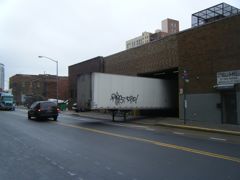
Between South 2nd and South 3rd.
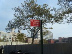
But the Greenway (and its precursor, the bifurcated bike lanes that were just installed on Kent Avenue) poses a very real and very immediate threat to the many businesses that continue to operate on the east side of the avenue. With the implementation of “No Stopping” rules on both sides of the street, businesses can no longer take deliveries curb side. Customers can no longer park in front, even just to load a purchase into their car. This is a huge problem, one that is symptomatic of the lack of planning that continues to plague Williamsburg and Greenpoint. Ironically, the bike lanes come just as new businesses are opening along Kent (with more to come as the retail components of new residential developments comes on line).
I will admit that I am somewhat less sympathetic to the parking issue. Cars – even those that are not moving – should not take precedence over open space, pedestrian walk ways and bike lanes. North of Broadway, the City has promised to make additional parking available on the side streets, though its not clear that has happened yet. South of Broadway is a different story. Because there are fewer side streets and more parking restrictions along Wythe Avenue, residents of Schaefer Landing are forced to park far away from home (unless they want to pony up $300 a month to park in the development’s garage). Worse yet, they can’t even stop in front of their building to drop off passengers.
(A lot of this latter problem could be solved if Schaefer Landing allowed all of their tenants to use the parking circle for drop offs. But in a pathetic separate-but-equal move, tenants of the affordable housing units are apparently not allowed to use the off-street drop-off area. I didn’t believe this when I heard it at the Board meeting, but I have since spoken directly with one of the tenant leaders who tells me it is true. He also tells me that his efforts to have the policy changed have been rebuffed by Schaefer Landing management. Classy.)
All of the problems with the Greenway are problems of implementation, and they are indicative of a complete lack of comprehensive transportation planning on the part of the City. Which really should not be a surprise to anyone. CB1 Transportation Chair Teresa Toro has been calling for a comprehensive transportation study for years. CB1 requested this during the 2005 rezoning, and was told it was not necessary. Every time the issue is raised, DOT says that existing transportation policy and infrastructure is adequate to meet our needs.
Chicken, meet roost.
The problem with Kent Avenue is not the Greenway. The problem is that DOT is asking Kent Avenue to do too much. They want Kent to be a two-way truck route, with existing manufacturing users on the east side of the street and new residential/commercial uses on the west side of the street. Add to that the temporary bike lanes (or the future Greenway), and there is just not enough room.
The answer is not to eliminate the bike lanes/Greenway. The answer is to reconfigure Kent Avenue so that the Greenway works for everyone. The first step should be to eliminate two-way traffic – make Kent one way northbound. This will increase traffic southbound on Wythe, but if Wythe is not a truck route, this added traffic should not be burdensome. (The major north/south truck routes should be along the through routes in the neighborhood – McGuinness Boulevard, Meeker Avenue, etc. With the transition to residential in the 2005 zoning, Kent Avenue is no longer needed as a major thoroughfare – it should handle local traffic only.) The only public transportation affected is the Q59 bus, which runs southbound on Kent from Grand to Broadway. That can easily be shifted over to Wythe as well (which is where the route ran when Kent was being repaved a year to two back).
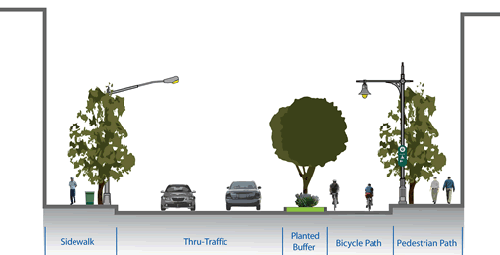
When you eliminate two-way traffic and the truck route, all of a sudden there is room for the stuff the community needs. A 15′ wide Greenway would occupy the west side of Kent, a 15′ traffic lane the center, and 15′ for parking and loading in the east lane. Businesses (which are all on the east side of the street) would be able to load, and customers could park. A drop-off area could be created across the street from Schaefer Landing (and the Mayor himself should call the owner of Schaefer Landing and tell them to drop their discriminatory drop-off policies).
These are also changes that could be implemented quickly. (DOT has already responded to one drop-off problem – that of the girls school South 9th and Kent by installing a bus loading zone (before that, school buses couldn’t stop in front of the school).) But there are also a host of bigger issues that need to be addressed along Kent Avenue. For instance, DOT refuses to consider stop lights on the Northside. From Metropolitan to Quay, there are no lights, turning Kent into a highway. Meanwhile, you have one new park (and another to come) and one new residential development (and four more to come). More and more pedestrians must now negotiate two directions of bike lanes and two directions of high-speed vehicle traffic to get from one side to another, with no crosswalk for blocks.
South 9th Street.
(On a related note, when the Greenway was first presented last Spring, both directions of bike traffic were located on the west side of the avenue. Because of the residential development, and the difficulty of having cars exiting those developments negotiate two-way bike traffic and other cars, DOT determined that it was safer to bifurcate the Greenway, which is what they have done with the new bike lane striping. I believe this is temporary, and that the Greenway itself will be only on the west side of the avenue (if not, it won’t be a very Greenway), but the problem could have been avoided entirely with a traffic light or two.)
Another long-range issue for Kent Avenue is the complete lack of public transportation south of Broadway. In addition to Schaefer Landing and 475 Kent, new residential development is under construction at the former Domsey site and more is planned just north (Kedem Winery) and just south (Certified Lumber) of Schaefer. That’s a lot of residences with no immediate access to buses or subways (or buses to take them to subways). (This is less of an issue on the Northside, where the Bedford L train is a short walk away, but it will be an issue if Domino gets built.)
These issues are all about one one-mile stretch of road. District-wide, we have similar problems and no comprehensive approach to fixing them. The neighborhood is changing pretty rapidly, but our transportation policies on a heavily-industrialzed past that the city zoned away three years ago. The crazy thing about all of this is that DOT clearly has their priorities in the right place when it comes to the big picture issues. Bike lanes and Greenways are good for the neighborhood and for the city as a whole. But because they can’t get the implementation right, they have managed to shift public sentiment against bike lanes and Greenways.
As a result of the CB1 meeting the other night, the Board will be writing to DOT asking them to do a comprehensive plan for the whole neighborhood, make the Greenway work, make businesses along Kent Avenue viable again, and address the parking and drop off issues. In other words, to do what should have been done in the first place. Given the passions on both sides, there is sure to be follow up until the issue is resolved.