Article 78

Like a lot of people in Greenpoint and Williamsburg, Stephen Pierson wants to turn back time and undo the waterfront rezoning for Greenpoint (and presumably Williamsburg). Unlike a lot of people, Pierson is running for City Council, so his ideas are getting a lot of attention.

As someone who has spent a lot of time on land use issues in Greenpoint and Williamsburg, and who put a lot of time and effort into fighting for the community’s position on the 2005 zoning and the many follow up actions and subsequent rezonings, I support this idea in concept. In reality, though, Pierson is making promises he can’t keep, and I think he knows it.

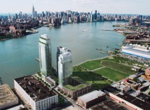
A coalition organized by Levin’s opponent for the Democratic nomination, Stephen Pierson, is pursuing an article 78 lawsuit to block the [Greenpoint Landing] development on the grounds that it is based on a grossly outdated Environmental Impact Statement.

First, let’s be clear about one basic fact – Article 78 is not going to reverse the 2005 rezoning or the Greenpoint Landing Development. The 120-day statute of limitations on filing an Article 78 action ran out almost 8 years ago (7 years and 361 days, but who’s counting?).

So if an Article 78 petition can’t stop the towers on the Greenpoint waterfront, what will it stop? Two things: affordable housing and parks.

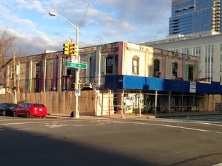
There are two current applications going through ULURP – one for Greenpoint Landing and one for 77 Commercial Street. If those applications are approved, one could petition to reverse those approvals under Article 78. But those approvals (which haven’t happened yet) are not the 2005 zoning, so the 40-story towers along most of the Greenpoint waterfront would not be touched. What would be touched is the affordable housing that the city committed to build in the 2005 Points of Agreement (over 600 units between Greenpoint Landing and 77 Commercial) and funding for parks and open space ($8 million), also promised by the city in 2005 (although the city promised $14 million back then). (This is not to say that either of these actions should be approved or are in any way a great deal for the community. In fact, a big part of these current actions are about the city trying to follow through on unfulfilled promises from 8 or 9 years ago, and a big problem with the current actions is the extent to which it gets the city off the hook for a lot more – but more on that later.)

Article78 tweets

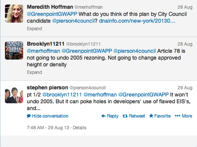
Pierson has already admitted that Article 78 is not going to reduce the as-of-right development on the waterfront from 40 stories to 15 (if it won’t undo 2005, it won’t undo 40 stories), but in articles and on his own campaign website he continues to say that Article 78 challenges are a viable tool in fighting the 40-story towers. To be clear – because Pierson seems unable to do so – IF an Article 78 challenge against the current ULURP applications for Greenpoint Landing/77 Commercial Street was successful, the court would throw out those approvals but the prior (2005) zoning would remain in place. In the case of the current Greenpoint Landing application, 40 stories and 4,000+ units of market-rate housing is the existing zoning. In the case of 77 Commercial, 15 stories and 275 units of market-rate housing is the current zoning. (Article 78 petitions are also very expensive – easily $100,000 or more – and, if SEQRA/ULURP procedures are followed (something that cadres of lawyers and environmental consultants are retained to make sure happens), Article 78 petitions are difficult to win.1)

The only way to reduce the height and density of the 2005 rezoning is do a new rezoning (something that Pierson says he will do). Personally, I think this would be extremely hard to do – not turning lead-into-gold impossible, but pretty damn close. You would be fighting against billions of dollars of vested development rights and the vested interests of a lot of labor and affordable housing advocates. Look at the 2010 Domino rezoning, which is actually bigger and denser than the 2005 rezoning, and provides far less open space and arguably less affordable housing – neighbors, community groups and the Community Board fought tooth and nail against this super-sized zoning, and lost.

‘If de Blasio becomes mayor, he might be more friendly to this idea. He might be able to scale back certain parts. In February of 2008, we scaled back, we down-zoned 13 blocks around Grand Street in Williamsburg. So, it’s possible.’

Pierson brings up the Grand Street rezoning a lot, but I don’t think he knows what that rezoning was all about. First off, Pierson had nothing to do with the Grand Street rezoning – his choice of pronouns is frankly insulting to the neighbors, city planners and community leaders (Diana Reyna was the true hero on this particular rezoning) who worked together to curtail the construction of “finger buildings” in Greenpoint and Williamsburg.

But to the substance of his claim, the Grand Street rezoning was actually a fairly small contextual rezoning, one of a series of actions undertaken after the 2005 rezoning in response to the spate of “finger buildings” being erected throughout Williamsburg. In response to these low-density height-factor-zoning towers, the Department of City Planning proposed contextual rezonings for about 200 blocks in Williamsburg and Greenpoint, changing the predominantly R6 zoning to R6A or R6B. The first action was actually a follow-up corrective action (FUCA) to the 2005 rezoning itself that put height limits on buildings along Metropolitan and Meeker Avenues (most of the rest of the 180 blocks rezoned in 2005 were given height limits). The Grand Street rezoning was the second action – about a dozen or so blocks got height limits as part of that action. The third, and by far the largest action was the 2009 Greenpoint/Williamsburg Contextual Rezoning that established height limits on 175 upland blocks from Commercial Street in the north to Maujer Street in the south. As a result of the 2005 zoning and the follow-up actions, about 400 blocks in north Brooklyn are contextually zoned with height limits. Yes, some of the height limits are too tall for some, but they are there.

Grand Street and all of the other follow up actions are completely irrelevant to rezoning the waterfront rezoning for one simple reason – density. None of these rezonings significantly changed the density of development in Greenpoint or Williamsburg. The height limitations were intended to curtail finger buildings and the abuse of the community facility bonus, not to reduce the base density of development. Rezoning the rezoning, on the other hand, would reduce the density of development by a factor of up to 50%. Not that that is a bad thing, but as a precedent for doing so, the scale and scope of the two actions have nothing to do with another.

1. Someone just pointed out to me that there was an Article 78 petition against the Greenpoint/Williamsburg Waterfront Rezoning. It was brought by TransGas Energy, a company that was trying to construct a large natural gas power plant at Bushwick Inlet. Despite their deep pockets and timely petition, they lost.

Older Than You Think

There has been a lot of excitement in some circles about the recent release of the City’s PLUTO dataset into the public realm. For those of who are not planning/geography nerds, PLUTO is the compilation of lot-level information on every building parcel in New York City – everything from use, zoning and height to assessed value and much, much more (Andrew Hill has a great slideshow overview). Until a week or so ago, you had to pay $300 per borough for this trove of information (or work at a University or other institution with a subscription). $300 per borough per year if you want to keep your data set up to date.

But now it is all available for free – and people are already exploring the data and making pretty maps, like this map of building dates put together by BKLYNER [free for a taste; sub. req. after]. A word of caution though – the PLUTO dataset has an amazing breadth of information, most of it highly accurate and quite up to date.

Unless you want to know how old your building is.

The data for building age (YearBuilt) is so flawed that you really should just delete that column from your dataset. If you read real estate ads, you will see a lot of buildings listed as 1898 or 1901. That number probably came from city records, and odds are 10 to 1 that number is wrong. Now take those odds and apply it to the 857,879 tax lots citywide and get an idea of the problem.

AllBrooklynChart
Data source: NYC PLUTO, 2010


If you look at the data, you can intuitively tell that something is wrong. A chart of 278,365 Brooklyn properties (above) shows almost no buildings constructed before 1895 (confirmed on BKLYNER’s map – note the dearth of blue and green buildings). The distribution of construction dates is heavily skewed to the early 20th century, with, paradoxically, the busiest five-year period of construction being 1930 to 1935 – the depths of the Great Depression (the “zero” bar represents vacant lots). PLUTO shows only 671 buildings in all of Brooklyn being constructed before 1895 – not even enough to register on the chart (the problem extends to Manhattan too, as the dearth of red on Hill’s map of 19th century makes clear). Think about that – according to PLUTO, in all of Brownstone Brooklyn and beyond, there are fewer than 700 buildings from the 19th century. Clearly there is something wrong here.

Looking at the number of buildings by year built, it is apparent that many buildings were assigned to five-year periods. Thus, 1920, 1930, 1925 and 1910 account for 40% of the buildings constructed. But there are also some dates that don’t fit the pattern – 1899 and 1931 each saw almost 20,000 buildings constructed; 1901, almost 15,000 (yet, only 22 buildings were constructed in 1902!). The explanation, I think is that 1899 represents the consolidation of Greater New York into a single municipal government, while 1901 may be a reflection of the enactment of the Tenement House Act of that year (it would have been important to know which buildings were “old law” and which were “new law”. 1931 is a puzzler – it may relate to the passage of the Multiple Dwelling Law in 1929, but that correlation there is less clear.

Building Dates
Source: Columbia Historic Preservation Studio, 2011


A comparison of actual building dates to PLUTO’s purported dates highlights the problem. In 2011, the students in my Columbia preservation studio prepared a preservation plan for Bushwick Avenue from Flushing Avenue south to Eldert Street. The students researched 1,944 parcels in the study area and identified relatively accurate dates of construction for almost all of them. They did this by researching the original block and lot files at Brooklyn DOB, poring through old issues of the Real Estate Record and Builders’ Guide and looking at historic insurance maps. Through this process, they were able to identify precise dates for about 1,500 buildings and narrowly-bracketed date ranges for another 400 or so (even so, their data is surely not 100% accurate either). The results of that effort can be seen in the map above, prepared as part of their larger plan [PDF].

PLUTOvActual
Data source: Columbia Historic Preservation Studio, 2011; NYC PLUTO, 2010

Above is a comparison of the actual dates of construction and the PLUTO estimated date of construction for all 2,175 parcels in the study area. Just as with the larger Brooklyn dataset, the City’s data for Bushwick Avenue skews to the period 1895 to 1934 (really 1899 to 1931). But Bushwick Avenue is not a 20th century street – even someone not versed in architecture history should be able to tell this just by walking down the street. Sure enough, the actual dates of construction shift the curve well to the left, with the majority of the buildings on the avenue having been constructed between 1880 and 1894. Which makes sense if you look at the buildings.

Not every neighborhood will have this exact distribution of building dates, but for much Brooklyn and Manhattan and some parts of the other boroughs, a distribution that skews to the early 20th century is just plain wrong. Used properly, the PLUTO data for building age can be useful, but only if you define 1901 as “everything before 1901” and then take the rest with a (smaller) grain of salt.

East Williamsburg, Queens

PS71

PS 71, East Williamsburg, L. I.
Photo: via ebay
Map

Last week, Gothamist had some fun with a Kalmon Dolgin real estate listing that purported to be in East Williamsburg when it was in fact in Ridgewood, Queens.

I’m sure Kalmon Dolgin was just fluffing their listing, as Gothamist said, but, there is a bit of historical accuracy to the moniker. Historically, there was a village just over the Queens border that was called East Williamsburg (Long Island!), as the above postcard will attest. This was completely distinct from the enlarged area of the town (and later city) of Williamsburg east of Union Avenue, which was annexed to the original town of Williamsburg (west of Union) in 1835.

Greenpoint Landing Lands Tonight

Park Tower Group Greenpoint

Greenpoint Landing (via Crain’s)
Architect: Handel Architects

Greenpoint Landing – the 22-acre development at the north end of the Greenpoint waterfront – is scheduled to make its public debut at a Community Board 1 meeting this evening*. From what I’ve heard to date, the project itself is largely as of right – the number of units, tower heights, tower massing, etc. are all what was approved in the 2005 waterfront rezoning (as Matt Chaban notes, the development has gone from glassy to a more “contextual” brick with punched window openings).

What is new is that the developer will be constructing the affordable housing that the city had committed to as part of the 2005 rezoning (Greenpoint Landing is building 20% inclusionary on their property, and building additional units on a city-owned site that is being wrapped into the project – the number of affordable units isn’t actually increasing from what was promised). The other new thing is the inclusion of a school as part of the development – this latter bit might be the only thing that requires an actual zoning modification.

There is another item on tonight’s agenda that will require a zoning modification – the new development up the street at 77 Commercial Street. That project is acquiring the air rights from the MTA parcel at 65 Commercial Street. The air rights purchase will allow the city to construct the park it committed to build at 65 Commercial, but also certainly taller and bulkier development on the adjacent 77 Commercial site.

The Greenpoint waterfront has been aslumber ever since the 2005 rezoning was approved (eight years ago this week). Greenpoint missed the last real estate boom, but seems destined to get caught up in this one, and when that happens, it will make the Northside and even Long Island City look quaint by comparison.

*Pardon the Facebook link – CB1’s website is too useless to link to.

Schizo Skyline

Stephen Jacob Smith is back, this time arguing that Two Trees’ Domino plan is somehow flawed because the upland zoning in Williamsburg is not dense enough. Where to begin – again?

But despite the best efforts of SHoP and Two Trees, the plan does not succeed in aping the natural parabolic shape of an organic thicket of towers found in midtown, downtown or even downtown Brooklyn. Nor could it—Williamsburg’s new planning regime, instituted in the 2005 rezoning and reinforced in 2009, makes sure of that…

A block or two away from the old Domino refinery, the skyline plummets to near zero—most sites across the street are zoned exclusively for industrial use, and cannot be developed beyond one and two stories. There is no gradual downward gradient.

Because the 2010 Domino zoning was a spot zoning – a really large one, but still spot zoning. When originally proposed in 2006 or so, the Domino rezoning actually included most of the surrounding industrial blocks. This made sense since the only reason those blocks were left out of the 2005 rezoning was because at that time Domino was still operational and had no plans to cease being so. Why did CPCR and the City take those blocks out – I have no idea, but it certainly wasn’t because of local “anti-growth” attitudes.

A block away, however, Mr. Smith’s dreamland actually does exist. East of Wythe Avenue, the Southside is zoned for medium to high density, largely without height limits. Because this area does have a lot of larger 6-story new-law tenements, it was not part of the 2009 contextual rezoning. This same context – R6 zoning with no height limits – also exists out along the L train in Bushwick. But not in between:

High-density building is allowed more than half a mile from the Bedford Avenue L, on the waterfront, but no housing is allowed at all on the blocks immediately adjacent to the Morgan Avenue stop. And it’s the pre-war neighborhoods, which sprouted naturally closest to the L, where residential development was most restricted in the rezonings.

OK – first of all, development did not sprout “naturally” along the L train. The L train was constructed as the Canarsie Line in the mid 1920s – well after 90% of the surrounding development, particularly that in the Northside, was constructed. The L train was a late addition, meant in part to connect the existing working class and industrial neighborhoods of Brooklyn to one another (and to Manhattan). One of those industrial neighborhoods was near the Morgan stop. That area is zoned industrial because it is a historically industrial area directly adjacent the canals of Newtown Creek and the LIRR freight spur. Maybe that zoning is outdated (I don’t think so, though I do think many other industrial areas are), but singling out one subway stop when the five stops before and the five stops after are in largely residential zones (some without those pernicious height limits) seems like cherry picking.

Northside

Looking at the photo to the right, you might be forgiven for thinking Smith has a point. But contrary to what the caption says “density differentials” are not that “par for the course on the waterfront.” The photo itself isn’t even real – it is clearly a rendering (by Toll Brothers, I assume) showing the full build out out of Northside Piers (the tower at left is just now under construction). To the north of Northside Piers is the Edge (3/4 of which is built out) and beyond that a park (because when you rezone a neighborhood for a population increase of 30,000, it helps to add some open space). And to the north of that is some low-scale industrial stuff that is also slated to become a park (that’s another story). Meanwhile, across Kent Avenue, most of the low-scale blocks shown in this rendering have been redeveloped or are in the process of being redeveloped, for 6- to 7-story residential. Even the hulking block-long building to the south of Northside Piers has been redeveloped – it now houses 242 residential units. All told, there are well over 1,000 new housing within two blocks of Northside Piers that are not shown in this image, and the density (not height) differential between the buildings on one side of Kent and those on the other is not really that dramatic.

This trope that low-scale neighborhoods are de facto low density is getting really tired, and no matter how many times Smith says it, it doesn’t make it true. As I pointed out the last time Smith raised this idea, there are actually a lot of unused development rights within the existing zoning for Williamsburg and East Williamsburg. A quick back-of-envelope calculation shows that much of the area is built to about two-thirds or three-quarters of its allowable floor area. And that’s just the existing housing stock – the two to (usually) three or four story vinyl-clad houses Smith abhors (but which, interestingly, people are willing to pay dearly for, and use as is, even when they are underbuilt by 50% – stupid market).

And this doesn’t begin to take account of the thousands of housing units at “projected development sites” identified in the 2005 rezoning that remain unbuilt. So even without rezoning for increased density, there is a lot more density to come. And capacity for plenty more built into the system.

Atlantic’s Credibility Crisis

Wow – Atlantic Cities let someone with no clue about development in Brooklyn write about development in Brooklyn. The basic premise of the article is that zoning (both use and FAR limits) is making housing more expensive by restricting the amount of new housing that can be constructed. In other words, the classic libertarian argument about land-use restrictions.

Let’s review:

According to data from the U.S. Census Bureau, the number of housing units in the five boroughs inched up an average of 0.5 percent annually between 2000 and 2010. That’s not even enough to keep pace with average U.S. population growth, which is about 1 percent per year.

The 2010 Census is so flawed, particularly with regard to Williamsburg and Greenpoint, that no credible argument can be based on its data. Remember, according to the census, much of North Brooklyn did not see a population increase between 2000 and 2010. Despite the very gentrification that Smith writes about, despite a building boom that has added thousands of new housing units since 2002 and despite a massive rezoning halfway through the decade that allowed for the creation of thousands more new housing units in formerly industrially-zoned areas. In all, something on the order of 4,000 new dwelling units (very conservatively estimated) have been added to the western parts of Greenpoint and Williamsburg since 2005 (the areas within and immediately adjacent to the 2005 rezoning). Hundreds if not thousands more have been added elsewhere in Greenpoint, Bushwick and the Southside.

Functionally, the industrial zoning along the waterfront and throughout Bushwick is hopelessly out of date. Urban manufacturing here is a shell of its former self. Car repair shops, wholesalers, warehouses and storage facilities are now the main tenants of Brooklyn’s “manfacturing core.”

What industrial zoning along the waterfront? 80% of the Williamsburg/Greenpoint waterfront was rezoned for residential use 7 years ago, and another 10% (Domino) in 2010. Hundreds of new housing units have been created on the Williamsburg waterfront, and hundreds more are coming to Greenpoint. There are three blocks of the Williamsburg waterfront that are still zoned manufacturing (between Grand and North 3rd) one of those blocks contains a power plant), and the other two.

Meanwhile, the remaining industrially-zoned areas of north Brooklyn are creating a lot of jobs. Good jobs, too. Look at the Brooklyn Navy Yard, a center of high-tech manufacturing and film production. Look at GMDC, which has a waiting list of small manufacturers. Look at the booming film production industry in Greenpoint. Historically, many people in north Brooklyn worked in north Brooklyn – not in Manhattan.

East Williamsburg actually has an abundance of underused land around Bushwick Creek, but Mayor Bloomberg and Brooklyn borough president Marty Markowitz don’t want to allow any residential development in the neighborhood, in order “to preserve the city’s manufacturing base.”

Bushwick Creek is not in East Williamsburg. It is not even a creek anymore. It is an inlet on the East River that divides Williamsburg and Greenpoint. Yes, the city created a small industrial carve out around Bushwick Inlet in 2005, and no, that carve out probably doesn’t make any sense.

…northern Brooklyn is underdeveloped. The hip neighborhoods around the L train, the main vehicle of gentrification in Williamsburg and Bushwick, are less than half as dense as Brooklyn neighborhoods like Crown Heights and Bed-Stuy.

Perhaps true – hard to tell from a jpeg of a map with no data sources listed (perhaps its from the census?). Regardless, much of Williamsburg and Greenpoint is actually under built compared to the allowable zoning. The potential density for north Brooklyn at current FAR limits is well above the actual density (in fact, it is probably comparable to the density shown in the fuzzy jpeg map, which seems to show much of brownstone Brooklyn at higher density than north Brooklyn – though all these areas have roughly the same zoned density).

Aesthetically, the vinyl-covered two- to four-story houses that dominate are some of the ugliest in the city. They lack the ornate cornices of their peers in south Brooklyn, and the brick patterns hidden behind the vinyl and stucco are plain compared to other pre-war styles.

So tear them down and we can build to a higher density. Zoning isn’t stopping that, and in fact that’s what is happening already (and has been happening very actively for a decade now). (And by the way, the brick is plain because a lot of those houses are pre-a-different-war – the Civil War; Williamsburg in particular has some of the oldest housing stock in the city.)

Problem is, from an infrastructure point of view, north Brooklyn is hurting. Unlike other areas of Brooklyn with higher population densities, north Brooklyn is not as richly served by public transit (if you pay attention to the map, the areas of highest density are along the public transit corridors), and it does not have as much park and open space as a lot of other areas. L trains run at capacity (in part because more newer residents are more likely to work in Manhattan, not locally), JMZ trains are rapidly gaining capacity (and neither line can be readily expanded), new bus lines, bike lanes and ferries are being added (but that only helps at the margins), parks and open space are overcrowded and over-utilized, and on and on. Sure, we could double the zoning density of North Brooklyn, but our infrastructure can’t even handle the thousands of people who have been added to the area to date, let alone the thousands more that will be added if currently as of right development continues apace.

Monster Island Going Down – What’s Next?

Monster Island, RIP

Monster Island, prepped for demolition.

The block-sized property on Kent Avenue between Metropolitan and North 1st is finally getting demolished. Sidewalk sheds and permits went up early this week, and demolition of one of the River Street buildings was in progress as of yesterday.

What the future holds for this site is unclear. The property – once home to Monster Island, Duff’s, Mollusk and other Williamsburg 2.0 establishments – is still zoned for manufacturing use. That zoning designation was always tenuous at best, but since the rezoning of Domino seems to make little sense. Con Ed has already cleared its site across River Street (also with no plans for redevelopment), and despite the earlier rumors, it seems unlikely that Chetrit, who owns this site, will be putting a Whole Foods here. There are no permits on DOB for this site, so it’s anyone’s guess what is in store. Perhaps a rezoning (it would make a lot of sense to rezone all of the remaining manufacturing blocks along Kent between South 3rd and North 3rd), perhaps a new hotel (which seems to be the new highest and best use for M-zoned lots in Williamsburg 3.0).

Rethinking Building Code, Post Sandy

From the Times, some opening thoughts on revamping the building code in a post-hurricane city. The focus for now is on how to build better in a rising-sea level world, versus just not building in Zone A at all (as a rather silly recent “resolution” from Community Board 1 wants).

As the Times notes, some projects have already gone beyond the current City code requirements for construction in a flood plain, and at least one of those (a recycling plant in Sunset Park) avoided flooding during Sandy as a result. Locally, the new development on the Williamsburg waterfront has also fared comparatively very well. While the flooding on this side of the river seems to have been less severe than it was just across the river, there was flooding. But Schaefer’s Landing, 184 Kent, Northside Piers and the Edge all came through the storm much better than a lot of other newer developments. Unlike many high-rises in lower Manhattan that remain unoccupiable and will be so for months, the systems in the Williamsburg developments survived and the buildings were occupiable pretty much as soon as the evacuation orders were lifted. I know at least one of our waterfront buildings took on a substantial amount of water during the storm surge, but had storm-surge mitigation mechanisms in place that worked, thus avoiding major damage within the building.

Are there lessons to be learned from the local experience, or were we just lucky? (Some of both, I suspect.)

Greenpoint Developer Wants to Build 10 Huge Towers, Giant Bridge

Manhattan Avenue Bridge
Vernon Avenue Bridge (demolished in 1954)
Source: Novelty Theater

It’s not exactly new news, but Gothamist has a piece up on the proposed mega-development at the top of Greenpoint. Not news because what’s proposed is exactly what the city approved in the 2005 waterfront rezoning. Aside from the proposed bridge to Hunters Point, the only real news is that it has taken so long for development to happen on the Greenpoint waterfront. No one has broken ground yet, but this is one of four projects that are actively in the pipeline. Taken together, these four projects would transform the north Greenpoint waterfront from Java Street to Commercial Street. (The same fate is in store for the southern part of the Greenpoint waterfront – why the northern projects are further along is a mystery to me.)

As for the bridge – connecting West Street to 2nd Street in Hunters Point South – it would be great to reconnect these two neighborhoods, but I’d much rather see it done the old fashioned way, running from Manhattan Avenue to Vernon Boulevard in Hunters Point. In addition to replacing an ages-old connection, a bridge at Manhattan Avenue would have the benefit of connecting two neighborhoods, not two developments.