Fight the 40-story Towers?

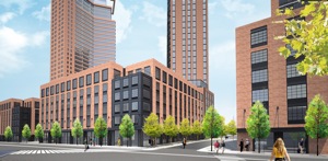
According to their Facebook invitation, ’40 story towers threaten the future of Greenpoint. The community has been shut out of the process. This is your chance to be heard.’

Actually, your chance to be heard was about nine years ago, when the zoning for the 40-story towers (and ton of new residential development in general) started the public review process. A lot of people fought very hard to make the community’s voice heard – we could have used your help back then.

Inclusionary Housing Program Not Making So Much Housing

According to a new study by Brad Lander’s office, the City’s inclusionary housing program hasn’t created as much affordable housing as the City predicted. That’s not really a surprise, and neither is it a surprise that most of the inclusionary housing generated has been on the Williamsburg waterfront and on the far west side of Manhattan at Hudson Yards. It’s not a surprise because those two areas are some of the few places where the incentives are deep enough to compel participation in the program. In most of Greenpoint & Williamsburg where the program was put in place, the incentive is really not that great, particularly once the market heats up.

Except on the Greenpoint waterfront – it will be big there.

Via WNYC

Ugliest, Scariest, Most Horrible

The last thing Greenpoint ever wanted was a wall of buildings. This is the ugliest, scariest, most horrible plan.

It would have been great if all these people cared back in 2004 or so when all of this was getting approved. Olechowski is right – there was a lot of activism within the community to get a better plan out of the rezoning (going back to the mid 1990s), but what was approved is what was approved.

And except for the height of 77 Commercial, just about everything here is what was approved in 2005. And the height of 77 Commercial has an actual community benefit attached to it – a new park next door at 65 Commercial. Whether that is a trade-off worth making is another question.

Greenpoint Landing Lands Tonight

Park Tower Group Greenpoint

Greenpoint Landing (via Crain’s)
Architect: Handel Architects

Greenpoint Landing – the 22-acre development at the north end of the Greenpoint waterfront – is scheduled to make its public debut at a Community Board 1 meeting this evening*. From what I’ve heard to date, the project itself is largely as of right – the number of units, tower heights, tower massing, etc. are all what was approved in the 2005 waterfront rezoning (as Matt Chaban notes, the development has gone from glassy to a more “contextual” brick with punched window openings).

What is new is that the developer will be constructing the affordable housing that the city had committed to as part of the 2005 rezoning (Greenpoint Landing is building 20% inclusionary on their property, and building additional units on a city-owned site that is being wrapped into the project – the number of affordable units isn’t actually increasing from what was promised). The other new thing is the inclusion of a school as part of the development – this latter bit might be the only thing that requires an actual zoning modification.

There is another item on tonight’s agenda that will require a zoning modification – the new development up the street at 77 Commercial Street. That project is acquiring the air rights from the MTA parcel at 65 Commercial Street. The air rights purchase will allow the city to construct the park it committed to build at 65 Commercial, but also certainly taller and bulkier development on the adjacent 77 Commercial site.

The Greenpoint waterfront has been aslumber ever since the 2005 rezoning was approved (eight years ago this week). Greenpoint missed the last real estate boom, but seems destined to get caught up in this one, and when that happens, it will make the Northside and even Long Island City look quaint by comparison.

*Pardon the Facebook link – CB1’s website is too useless to link to.

Greenpoint Landing – Yes, It’s Coming

Greenpointers needs to stop being shocked – SHOCKED! – that massive high-rise development is coming to their waterfront.

Since 2005, it has been a question of when, not if, the Greenpoint waterfront will look like Long Island City, Northside Piers, the Edge, Schaefer Landing and all the other towers-to-be that will one day line the East River.

Atlantic’s Credibility Crisis

Wow – Atlantic Cities let someone with no clue about development in Brooklyn write about development in Brooklyn. The basic premise of the article is that zoning (both use and FAR limits) is making housing more expensive by restricting the amount of new housing that can be constructed. In other words, the classic libertarian argument about land-use restrictions.

Let’s review:

According to data from the U.S. Census Bureau, the number of housing units in the five boroughs inched up an average of 0.5 percent annually between 2000 and 2010. That’s not even enough to keep pace with average U.S. population growth, which is about 1 percent per year.

The 2010 Census is so flawed, particularly with regard to Williamsburg and Greenpoint, that no credible argument can be based on its data. Remember, according to the census, much of North Brooklyn did not see a population increase between 2000 and 2010. Despite the very gentrification that Smith writes about, despite a building boom that has added thousands of new housing units since 2002 and despite a massive rezoning halfway through the decade that allowed for the creation of thousands more new housing units in formerly industrially-zoned areas. In all, something on the order of 4,000 new dwelling units (very conservatively estimated) have been added to the western parts of Greenpoint and Williamsburg since 2005 (the areas within and immediately adjacent to the 2005 rezoning). Hundreds if not thousands more have been added elsewhere in Greenpoint, Bushwick and the Southside.

Functionally, the industrial zoning along the waterfront and throughout Bushwick is hopelessly out of date. Urban manufacturing here is a shell of its former self. Car repair shops, wholesalers, warehouses and storage facilities are now the main tenants of Brooklyn’s “manfacturing core.”

What industrial zoning along the waterfront? 80% of the Williamsburg/Greenpoint waterfront was rezoned for residential use 7 years ago, and another 10% (Domino) in 2010. Hundreds of new housing units have been created on the Williamsburg waterfront, and hundreds more are coming to Greenpoint. There are three blocks of the Williamsburg waterfront that are still zoned manufacturing (between Grand and North 3rd) one of those blocks contains a power plant), and the other two.

Meanwhile, the remaining industrially-zoned areas of north Brooklyn are creating a lot of jobs. Good jobs, too. Look at the Brooklyn Navy Yard, a center of high-tech manufacturing and film production. Look at GMDC, which has a waiting list of small manufacturers. Look at the booming film production industry in Greenpoint. Historically, many people in north Brooklyn worked in north Brooklyn – not in Manhattan.

East Williamsburg actually has an abundance of underused land around Bushwick Creek, but Mayor Bloomberg and Brooklyn borough president Marty Markowitz don’t want to allow any residential development in the neighborhood, in order “to preserve the city’s manufacturing base.”

Bushwick Creek is not in East Williamsburg. It is not even a creek anymore. It is an inlet on the East River that divides Williamsburg and Greenpoint. Yes, the city created a small industrial carve out around Bushwick Inlet in 2005, and no, that carve out probably doesn’t make any sense.

…northern Brooklyn is underdeveloped. The hip neighborhoods around the L train, the main vehicle of gentrification in Williamsburg and Bushwick, are less than half as dense as Brooklyn neighborhoods like Crown Heights and Bed-Stuy.

Perhaps true – hard to tell from a jpeg of a map with no data sources listed (perhaps its from the census?). Regardless, much of Williamsburg and Greenpoint is actually under built compared to the allowable zoning. The potential density for north Brooklyn at current FAR limits is well above the actual density (in fact, it is probably comparable to the density shown in the fuzzy jpeg map, which seems to show much of brownstone Brooklyn at higher density than north Brooklyn – though all these areas have roughly the same zoned density).

Aesthetically, the vinyl-covered two- to four-story houses that dominate are some of the ugliest in the city. They lack the ornate cornices of their peers in south Brooklyn, and the brick patterns hidden behind the vinyl and stucco are plain compared to other pre-war styles.

So tear them down and we can build to a higher density. Zoning isn’t stopping that, and in fact that’s what is happening already (and has been happening very actively for a decade now). (And by the way, the brick is plain because a lot of those houses are pre-a-different-war – the Civil War; Williamsburg in particular has some of the oldest housing stock in the city.)

Problem is, from an infrastructure point of view, north Brooklyn is hurting. Unlike other areas of Brooklyn with higher population densities, north Brooklyn is not as richly served by public transit (if you pay attention to the map, the areas of highest density are along the public transit corridors), and it does not have as much park and open space as a lot of other areas. L trains run at capacity (in part because more newer residents are more likely to work in Manhattan, not locally), JMZ trains are rapidly gaining capacity (and neither line can be readily expanded), new bus lines, bike lanes and ferries are being added (but that only helps at the margins), parks and open space are overcrowded and over-utilized, and on and on. Sure, we could double the zoning density of North Brooklyn, but our infrastructure can’t even handle the thousands of people who have been added to the area to date, let alone the thousands more that will be added if currently as of right development continues apace.

Leaders Want Bushwick Rezoning So It’s Not the Next Williamsburg

Bushwick – one of the last unlimited height zones in northern Brooklyn – is ripe for a raft of finger-type buildings. A year and a half ago, the local community board’s land use committee showed little interest in the threat of height-factor buildings. Now, with development on the upswing throughout the area, the community may be too late to the game.

McGuinness Rezoning

Mcguinness render

231 McGuinness rendering
Michael Kwartler and Associates
[photo: Greenpointers]


Greenpointers has a report on a proposed rezoning for the block of McGuinness between Calyer and Greenpoint – aka, the “Blockbuster” site (remember Blockbuster? back in the 20th century they used to rent movies), across from Key Food.

CB1’s Land Use committee held a hearing on the project last week (which I missed), and the full board will presumably vote on the application at this Wednesday’s full board meeting.

The proposal itself is to rezone this block of McGuinness from M1 to R7-A (which would allow a building of the scale depicted above – hopefully this zoning placeholder will be developed into something a little insipid design-wise once the rezoning is approved). As Greenpointers helpfully points out, R7-A is the “type of zoning [that] is found along the avenues in the East Village”. It also happens to be the type of zoning that is found along the west side of McGuinness from Calyer south to Driggs (north of Greenpoint Avenue, the west side of the street is zoned R6-A, a slightly smaller medium-density zoning). The blocks from Calyer south were up zoned in 2009 as part of the larger contextual rezoning of inland Williamsburg and Greenpoint (City Planning looks to put higher density residential on avenues in part to encourage commercial development and in part make the use of inclusionary housing bonuses more viable – and yes, this application includes an expansion of the inclusionary program to this block).

This particular site was left out of the 200-block 2009 rezoning only because that rezoning focused solely on height limits and did not involve any use changes. Had the 2009 rezoning allowed change of use anywhere, it probably would have allowed it here (the owner of the property had already started the process, at least informally, before 2009).

So the main question here is not whether the property should be rezoned from manufacturing to residential like the rest of this side of the boulevard, but whether it should be rezoned to match the medium-density blocks to the north or the medium-to-high-density blocks to the south.