Interesting use of quotation marks by the Post.
“Rape”
Former HPD Commissioner to Head CPC, Domino Developer
Rafael Cestero, who headed HPD for two years, will take over the helm at Community Preservation Corporation/CPC Resources (the latter is the developer of the Domino project). Michael Lappin, who was CEO of CPC/CPCR for 30 years, announced his retirement in November.
C. P. H. Gilbert – The Permastone Years

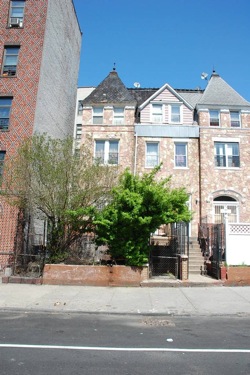
705 and 707 Willoughby Avenue
Architect: C. P. H. Gilbert?, 1885
Photo: via PropertyShark
Chris Gray and his Streetscapes column were back in Brooklyn this week, profiling one of the great architects of the Gilded Age. Much of Gilbert’s early work was done in the Park Slope area, but his first Brooklyn commission may have been this pair of buildings on Willoughby Avenue in Bed-Stuy.
Despite the permastone, there are some traces of old stuff, particularly the profile of the roof and the cresting atop it. And the massing of the buildings looks quite consistent with Gilbert’s other work of the period.
The East River Ferry App (and Surcharge?)
The East River Ferry giveth, and the East River Ferry (maybe) taketh away.
NY Waterway has released an app that lets you but tickets on the iPhone/iPad (no word on apps for Android or other mobile devices). The app free, though obviously the tickets aren’t. In addition to buying tickets and checking schedules, the app will let you uptown commuters check the whereabouts of the next shuttle bus too. All very nice stuff.
On the flip side, starting on Monday the ferry might be adding a $2 surcharge for passengers who buy tickets on the boat. Tickets bought through the ticket kiosks will still be $4 (or $140 for a monthly pass). But, if you are like me and are running late for the boat with no ticket in hand, you might get hit with a surcharge (luckily, there’s an app for that!).
This, at least, is what the attendants on the boat were telling customers. However, Metro is reporting that the surcharge is not happening, and the PR rep for the East River Ferry told Metro that “there are no changes to the fare structure at this time”.
UPDATE: Via Twitter, East River Ferry confirms that there is no surcharge. And, via comments, Withers confirms the existence (and greatness) of an Android app too. Last, I tried out the ticket purchase on the iPhone tonight, and it too is great.
The Hot Seat: Laura Treciokas
Brownstoner interviews Laura Treciokas, co-chair of Friends of Bushwick Inlet Park and a Where’s Our Park? organizer.
Scottish Scientists Re-create 100-Year-Old Whisky
I had no idea you could carbon date whisky.
Brooklyn History Photo of the Week
Clinton Avenue at Fulton Street
March, 1888
Photo: A. A. Martense via BHS.
This photo, taken on Clinton Avenue at Fulton Street in March 1888 comes via the Brooklyn Historical Society’s blog. BHS has the full details, but what I like about the photo is the signage on the side of the building: trusses, crutches, and the Sutherland Sisters Hair Grower and Scalp Cleaner (which may have something to do with the “electricity applied” in the sign at the far right).
Skee-Ball Manufacturer Sues Williamsburg Skee-Ball Bar Full Circle
Regardless of the merits of the suit, this seems to be an incredibly stupid move on the part of Skee-Ball, Inc.
Judge Grants Injunction on Broadway Triangle
State Supreme Court Judge Emily Goodman has granted a preliminary injunction that bars the City from moving forward with the development of affordable housing in the Broadway Triangle area. The suit, brought by the NY Civil Liberties Union, Brooklyn Legal Services Corporation A, Emery Celli Brinckerhoff & Abady and the Broadway Triangle Community Coalition, alleges that the City’s 2006 rezoning of Broadway Triangle violates the Federal Fair Housing Act, in that it would increase racial segregation in the neighborhoods surrounding the Broadway Triangle. Judge Goodman, in granting the injunction, ruled that the “plaintiffs had demonstrated the likelihood that they would succeed at trial on the merits of the case” (in other words, the case itself has not yet been litigated).
The Broadway Triangle rezoning covers a small swath of land north of Flushing Avenue and west of Broadway. The area that the City rezoned lies within Community Board 1, but borders directly on CB3. Most of the area that was rezoned is privately owned, but a number of City-owned parcels were set aside for the development of affordable housing. 50% of that affordable housing would be set aside for residents of CB1 (such set-asides are standard in the City). The plaintiffs contend that because Williamsburg (CB1) is predominantly white (about 60% according to the evidence presented by the plaintiffs), and Bedford-Stuyvesant is predominantly (77%) black, that the set aside would perpetuate and increase the racial segregation between the two neighborhoods. A demographer retained by the plaintiff found that only 3% of residents in the new housing would be black.
The plaintiffs’ argument – accepted by Judge Goodman – is that the City is required under Federal law to conduct an analysis on the racial impact of all rezonings. Judge Goodman wrote in her ruling that there “can be no compliance with the Fair Housing Act where defendants never analyzed the impact of the community preference”.
The issues on which the injunction was issued are ones that (to my recollection) never came up during the protracted fight over the Broadway Triangle rezoning, and certainly never came up in any of the other large and small rezonings in North Brooklyn that were enacted by the City over the past decade. On the merits, it stands to reason given the demographics of the two neighborhoods that the set aside would favor whites applying for affordable housing. But many other rezonings have created (or could create) “dramatic racial disparities”.
As NYCLU’s press release notes, this ruling has implications far beyond Broadway Triangle:
This decision puts the city is clearly on notice: When it proceeds to develop housing – whether in the Broadway Triangle or anywhere else – it must evaluate the potential impact on segregation and develop projects that include the entire community and will create more integrated neighborhoods.
So the bigger question is, how does this effect other rezonings (past and future)? Is a racial analysis required for all housing types (affordable and market rate)?
Fatty ‘Cue Williamsburg Closed (But Not for Good)
Grub Street has the details.

