
Competing renderings of Greenpoint Landing are the starting point for a look at how renderings are used to sell – and stop – development projects.
Idealized or Caricature, Architectural Renderings Are Weapons in Real Estate
CB4 Might Have Approved Rezoning of Rheingold Brewery Against the Law
The open meeting law does apply to community boards. Public participation is not guaranteed, but open meetings should be. That said, there were other reporters in attendance, so was the meeting actually closed to the public?
Quadriad Townhouses
The row houses at the former Quadriad site – the longest running development saga in neighborhood history – are finally, finally finished and ready to go market. If you count the time spent trying to turn this project into a 23-story building, these row houses have been at least seven years in the making.
The row houses themselves – designed by RKT&B and Stan Allen – are very nice, particularly the way they are set back from the street to create a sort of public/private area of front yards. But $2.4 million a pop, for a house that is less than 15′ wide?
McCarren Park Pool outscores Barclays Center
Seriously?
The area around McCarren was developed into condoland years ago (a lot of projects predate the 2005 zoning). I’d bet that the prior redevelopment, not to mention the massive rezoning of the area in 2005, had a lot more to do with the price of development sites in the area than a few million gallons of water in a pool do (as fantastic as that pool might be).
I can’t see the actual report from Eastern Consolidated, but the total volume comparison is BS. Look at $/sf (mentioned in the Crain’s report), and the areas are a lot closer (though McCarren still “wins” by 20%, not 200%).
And then decide which is the apple and which is the orange.
Post-Sandy Rezoning at CB1
The agenda for Community Board 1’s Land Use Committee meeting tonight is a pretty sleepy affair – two BSA applications, both of which are retreads that the Board has heard in years past. However, there is one very important agenda item, which is a presentation by City Planning on the City’s proposed Flood Resilience Zoning Text Amendment, which modifies the zoning to allow new development to meet the new flood zone requirements.
I saw the presentation last week at CB2, and what the city is proposing is to modify the zoning to allow flood-resilient design with no (or minimal) impact on development rights. For those of you hoping that Sandy and the new FEMA flood zones will make development in Zone A impossible, this makes development possible. Actually, post-Sandy regulations don’t make development in Zone A impossible in the first place, in simple terms, they only restrict development and use at the base of buildings. These changes to the zoning will, in some case, permit taller development to compensate for the fact that ground floors now need to be flood-proofed in some manner and will no longer be usable floor area. Other modifications include not counting construction below the flood level as floor area and allowing greater amounts of rooftop mechanical area.
When: Tonight (June 25), 6:30 pm
Where: CB1 offices, 435 Graham Avenue
South Williamsburg Creeps North
An investment group led by Waterbridge Capital’s Joel Schreiber has closed on the purchase of nearly an entire South Williamsburg block, with plans for high-end retail development, the Wall Street Journal reported… Waterbridge is looking to bring “high-end retail,” tenants to the block, a source familiar with the transaction told the Journal. Doing so would continue the transformation of South Williamsburg into a trendy retail destination, with stores such as Whole Foods making their way to the neighborhood.
$30 million for a South Williamsburg block?!? And a Whole Foods?!!?
Oh, by “South Williamsburg” they really mean “Bedford and Driggs avenues and North Third and North Fourth streets”. (And Waterbridge already acquired half this block last year – remember J. Crew?
Greenpoint Landing Lands Tonight
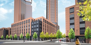
Greenpoint Landing (via Crain’s)
Architect: Handel Architects
Greenpoint Landing – the 22-acre development at the north end of the Greenpoint waterfront – is scheduled to make its public debut at a Community Board 1 meeting this evening*. From what I’ve heard to date, the project itself is largely as of right – the number of units, tower heights, tower massing, etc. are all what was approved in the 2005 waterfront rezoning (as Matt Chaban notes, the development has gone from glassy to a more “contextual” brick with punched window openings).
What is new is that the developer will be constructing the affordable housing that the city had committed to as part of the 2005 rezoning (Greenpoint Landing is building 20% inclusionary on their property, and building additional units on a city-owned site that is being wrapped into the project – the number of affordable units isn’t actually increasing from what was promised). The other new thing is the inclusion of a school as part of the development – this latter bit might be the only thing that requires an actual zoning modification.
There is another item on tonight’s agenda that will require a zoning modification – the new development up the street at 77 Commercial Street. That project is acquiring the air rights from the MTA parcel at 65 Commercial Street. The air rights purchase will allow the city to construct the park it committed to build at 65 Commercial, but also certainly taller and bulkier development on the adjacent 77 Commercial site.
The Greenpoint waterfront has been aslumber ever since the 2005 rezoning was approved (eight years ago this week). Greenpoint missed the last real estate boom, but seems destined to get caught up in this one, and when that happens, it will make the Northside and even Long Island City look quaint by comparison.
*Pardon the Facebook link – CB1’s website is too useless to link to.↩
Bushwick Mall
Bushwick Daily has pictures from a Massey Knakal brochure marketing a proposed “Bushwick” Mall on Bogart Street in East Williamsburg. It’s not really clear if Massey Knakal is marketing the property (i.e., trying to entice someone to develop it) or if they are trying to market the project (i.e., someone is already planning to build this and is looking for tenants). Either way, this project seems to be more about the Bushwick Hotel than the Bushwick Mall.
It’s Much More Local than Williamsburg
Whatever that means – I guess anything in Greenpoint is more local to Greenpoint than Williamsburg.
Sometime pretty soon, development along West Street is going hit. And when that happens, Greenpoint (this section at least) is going to look a hell of a lot like Williamsburg. And like Long Island City.
Schizo Skyline
Stephen Jacob Smith is back, this time arguing that Two Trees’ Domino plan is somehow flawed because the upland zoning in Williamsburg is not dense enough. Where to begin – again?
But despite the best efforts of SHoP and Two Trees, the plan does not succeed in aping the natural parabolic shape of an organic thicket of towers found in midtown, downtown or even downtown Brooklyn. Nor could it—Williamsburg’s new planning regime, instituted in the 2005 rezoning and reinforced in 2009, makes sure of that…
A block or two away from the old Domino refinery, the skyline plummets to near zero—most sites across the street are zoned exclusively for industrial use, and cannot be developed beyond one and two stories. There is no gradual downward gradient.
Because the 2010 Domino zoning was a spot zoning – a really large one, but still spot zoning. When originally proposed in 2006 or so, the Domino rezoning actually included most of the surrounding industrial blocks. This made sense since the only reason those blocks were left out of the 2005 rezoning was because at that time Domino was still operational and had no plans to cease being so. Why did CPCR and the City take those blocks out – I have no idea, but it certainly wasn’t because of local “anti-growth” attitudes.
A block away, however, Mr. Smith’s dreamland actually does exist. East of Wythe Avenue, the Southside is zoned for medium to high density, largely without height limits. Because this area does have a lot of larger 6-story new-law tenements, it was not part of the 2009 contextual rezoning. This same context – R6 zoning with no height limits – also exists out along the L train in Bushwick. But not in between:
High-density building is allowed more than half a mile from the Bedford Avenue L, on the waterfront, but no housing is allowed at all on the blocks immediately adjacent to the Morgan Avenue stop. And it’s the pre-war neighborhoods, which sprouted naturally closest to the L, where residential development was most restricted in the rezonings.
OK – first of all, development did not sprout “naturally” along the L train. The L train was constructed as the Canarsie Line in the mid 1920s – well after 90% of the surrounding development, particularly that in the Northside, was constructed. The L train was a late addition, meant in part to connect the existing working class and industrial neighborhoods of Brooklyn to one another (and to Manhattan). One of those industrial neighborhoods was near the Morgan stop. That area is zoned industrial because it is a historically industrial area directly adjacent the canals of Newtown Creek and the LIRR freight spur. Maybe that zoning is outdated (I don’t think so, though I do think many other industrial areas are), but singling out one subway stop when the five stops before and the five stops after are in largely residential zones (some without those pernicious height limits) seems like cherry picking.
Looking at the photo to the right, you might be forgiven for thinking Smith has a point. But contrary to what the caption says “density differentials” are not that “par for the course on the waterfront.” The photo itself isn’t even real – it is clearly a rendering (by Toll Brothers, I assume) showing the full build out out of Northside Piers (the tower at left is just now under construction). To the north of Northside Piers is the Edge (3/4 of which is built out) and beyond that a park (because when you rezone a neighborhood for a population increase of 30,000, it helps to add some open space). And to the north of that is some low-scale industrial stuff that is also slated to become a park (that’s another story). Meanwhile, across Kent Avenue, most of the low-scale blocks shown in this rendering have been redeveloped or are in the process of being redeveloped, for 6- to 7-story residential. Even the hulking block-long building to the south of Northside Piers has been redeveloped – it now houses 242 residential units. All told, there are well over 1,000 new housing within two blocks of Northside Piers that are not shown in this image, and the density (not height) differential between the buildings on one side of Kent and those on the other is not really that dramatic.
This trope that low-scale neighborhoods are de facto low density is getting really tired, and no matter how many times Smith says it, it doesn’t make it true. As I pointed out the last time Smith raised this idea, there are actually a lot of unused development rights within the existing zoning for Williamsburg and East Williamsburg. A quick back-of-envelope calculation shows that much of the area is built to about two-thirds or three-quarters of its allowable floor area. And that’s just the existing housing stock – the two to (usually) three or four story vinyl-clad houses Smith abhors (but which, interestingly, people are willing to pay dearly for, and use as is, even when they are underbuilt by 50% – stupid market).
And this doesn’t begin to take account of the thousands of housing units at “projected development sites” identified in the 2005 rezoning that remain unbuilt. So even without rezoning for increased density, there is a lot more density to come. And capacity for plenty more built into the system.