Post-Sandy Rezoning at CB1

The agenda for Community Board 1’s Land Use Committee meeting tonight is a pretty sleepy affair – two BSA applications, both of which are retreads that the Board has heard in years past. However, there is one very important agenda item, which is a presentation by City Planning on the City’s proposed Flood Resilience Zoning Text Amendment, which modifies the zoning to allow new development to meet the new flood zone requirements.

I saw the presentation last week at CB2, and what the city is proposing is to modify the zoning to allow flood-resilient design with no (or minimal) impact on development rights. For those of you hoping that Sandy and the new FEMA flood zones will make development in Zone A impossible, this makes development possible. Actually, post-Sandy regulations don’t make development in Zone A impossible in the first place, in simple terms, they only restrict development and use at the base of buildings. These changes to the zoning will, in some case, permit taller development to compensate for the fact that ground floors now need to be flood-proofed in some manner and will no longer be usable floor area. Other modifications include not counting construction below the flood level as floor area and allowing greater amounts of rooftop mechanical area.

When: Tonight (June 25), 6:30 pm
Where: CB1 offices, 435 Graham Avenue

Above the Flooded Plain – Did New Waterfront Developments Fare Better?

Sandy’s high tide receded, and the buildings on the waterfront in Long Island City stood like sentries on the coast—dry, fully inhabited and powered up almost as though no superstorm had ever occurred.

The situation was much the same in Williamsburg, best as I can tell. The new buildings came through relatively unscathed, despite flooding around them. I don’t know if any of the new Williamsburg buildings took special measures to mitigate 100-year flood conditions, but I know that 184 Kent did, and they worked.

One caveat here (and in LIC) is that the flooding was relatively light. There was definitely flooding, but compared to what was happening across the river and in places like Red Hook and even DUMBO, we seem to have gotten the least of it. Still, like LIC, none of the Williamsburg waterfront developments had to be taken out of service.
Getting to Work

The L train is still out, but getting to Manhattan from North Brooklyn should be a little bit easier tomorrow. The M and the J trains are both going over the Williamsburg Bridge. The J will only go as far as Essex Street, but the M will have its full route through midtown reinstated. The 7 train is also running to Manhattan, though you’ll have to a bus to L.I.C. to pick it up – the G train remains suspended (the only line completely out of commission now). The full rundown of service changes is posted at the MTA website.

If you need to get downtown, the East River Ferry is probably your best bet, what the the shortened J and no L service to Manhattan. With the exception of Greenpoint’s India Street landing, the ferry was running regular service as of today (Sunday), and they expect to have India Street open Monday morning. Expect long lines at the ferry, but if it is like last week, everyone will get on.

Is Brooklyn a Disaster Area?

No.

A hurricane hit Brooklyn dead on, and the damage we suffered was pretty minimal. Anytime you can say that, you are lucky. Brooklyn (and all of New York City) was very lucky.

We planned well and were very well prepared, but at the end of the day, we were very lucky.

Huge swaths of upstate New York, New Jersey and Vermont were very unlucky.

We have ways of dealing with such bad luck. One such way is to declare the affected areas a disaster zone and the Federal government puts money towards alleviating the disaster conditions. The fact that Brooklyn was not declared a disaster area does not mean that we were screwed. It means that we were lucky. I’m as much of a Brooklyn booster as the next person, but let’s just count our blessings and move on.

To review, Brooklyn is not a disaster area.

Upstate NY is a disaster area.

No matter how many sidewalk tree pits in Brooklyn were affected, we should not be clamoring for disaster-zone declarations. We should be thanking our lucky stars that a hurricane hit us dead on and caused so little damage, and then we should be opening up our hearts and wallets to fellow New Yorkers upstate and fellow Americans throughout New Jersey and New England.

A lot of us were lucky, some of us weren’t. Let’s help the people who weren’t and stop trying to score political points – local or national – off of other people’s misfortune.

Hurricane Irene

The exact track of Hurricane Irene is still a big unknown, but it sure is looking likely that it will dump a lot of wind and water on NYC come Sunday or Monday (or both). The latest tracking (taken with a big grain of salt) even have the eye of the storm going along the Queens/Nassau border.

irene-map.png

Source: NYC Office of Emergency Management

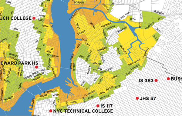
So it seems like a good time to dust off this map and remind people in North Brooklyn that a lot of us live in flood-prone areas (you can download the full map here). The areas in orange “face the highest risk of flooding from a hurricane’s storm surge”, and include all low-lying coastal areas. The areas in yellow (which includes just about all of Greenpoint, the industrial areas of East Williamsburg, and parts of South Williamsburg) “may experience storm surge flooding from a MODERATE (Category 2 and higher) hurricane”. Areas in green (mostly on the Northside and just in on the Williamsburg waterfront) “may experience storm surge flooding from a MAJOR (Category 3 & 4) hurricane” making a more or less direct hit on the NYC (“unlikely” according to the City). The areas in white (the Southside and East Williamsburg residential areas) are unlikely to see any storm surge flooding.

You can find exactly which zone you are in – and where the nearest evacuation center is – here, and you can find the City’s Hurricane Guide here.