Thoughts on River Ring

River Ring – the proposed rezoning by Two Trees of the former Con Ed site at Metropolitan and River Street – kicks off its ULURP review with a Community Board 1 Land Use committee meeting on Wednesday. Hopefully the CB recommends for changes but does not follow the lead of those who want to kill the project outright. This is a chance to rezone one of the last waterfront parcels on the East River, locking in a significant open space connector, affordable housing and more.

First off, this site should be residential. Period.

River Ring master plan

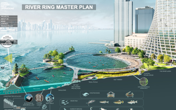
River Ring Master Plan
via FieldOps

There is no valid public policy reason to leave this zoned for heavy manufacturing. It should be smaller (floor area), which will make it shorter (not a big deal for me, but everyone else keys on the height). The open space is visionary and should be a model for future waterfront development – every developer should be held to this standard. It has everything community activists have been clamoring for and will connect the Southside waterfront and the rest of the neighborhood. There should be more affordable housing and it should be more affordable. 30% to 35% of the units, at a project-wide average AMI of 40%.

Hopefully CB1 supports the residential zoning *with* conditions. As they did for the 2010 Domino Rezoning (pre-Two Trees). In 2010 the CB did not say that residential use was inappropriate at Domino – rather that developer was trying to supersize the density. They should say the same thing here – support residential use, affordable housing and open space, but see it done better. (This would also be consistent with CB1’s District Needs statement, which lists affordable housing as the top TWO (of three) key issues for the community. It would also be in line with CB1 recommendations on other waterfront projects – Kedem Winery (420 Kent), Certified Lumber (Rose Plaza) and Shaefer Landing. Saying that this one parcel should be kept as M3 zoning doesn’t make sense in light of all these prior recommendations.)

There really is no valid public policy reason to leave the former Con Ed property zoned for M3 (heavy manufacturing). What kind of residential and how much can be debated, but if you are arguing to leave this as manufacturing you are not engaging in an honest debate. (The only other valid use I could see here is a public park. That would cost upwards of $300M for acquisition and construction – given the City’s track record at Bushwick Inlet, I’m not holding my breath. Not to mention that Parks would never build a build a waterfront park to the level of quality and design that Two Trees is proposing.)

This site should have been rezoned for residential years ago. In 2005 Domino was still in operation and it made sense to leave the area from Bway to N3 as manufacturing. But Domino closed shop just as that rezoning was going through, making the M zoning has been an anachronism. 11 years ago, when the first Domino Rezoning came through CB1, I asked why the City wasn’t developing a plan for the whole area – I still think that they should have. But instead, these parcels have been rezoned piecemeal – zoning, not planning, once again is the norm in NYC.

How much residential? I do think that the density being proposed is too much. Not a lot too much, but a bit too much. Back of the envelope, maybe 10% too much – the zoning should be straight R8, 6.5 FAR with the inclusionary bonus, same as the rest of the waterfront towers. (Yes, the waterfront sites from the 2005 Greenpoint-Williamsburg waterfront rezoning have a blended R6/R8 zoning, but on zoning lots that are 2 to 3 times the size of River St. and go all the way out to Kent/West. Blended zoning here would kill the affordable cross subsidy.)

Two Trees is also seeking a zoning waiver to reduce parking below what is required by zoning. Grant it. More parking means more cars, there is solid documentation for this. And more parking also means less affordable housing, there is solid documentation for that too.

In terms of the overall proposal, I love the waterfront access and open space. Field Ops design is truly transformative and is pretty much everything that open space advocates in the community have been asking for for years. It is resilient, both diurnally and annually. It is the first truly resilient open space on 4 miles of waterfront. It brings the public to the water without bulkheads, wharves or “get-downs”. It avoids the use of rip-rap and other unfriendly barriers between people and the water. The design reuses the pod wharves from the Con Ed site in creative ways to deal with the tides and currents of the East River. Most importantly, it CONNECTS the waterfront – the Northside esplanades to Grand Ferry Park, something that I and others have been advocating for years now. And it does so in a way that is a thousand times better than the waterfront esplanades of the 2005 rezoning. (Like at Domino, Two Trees promises to maintain the park rather than turning it over to Parks Department to manage – that is a very good thing too.)

(Also worth noting here for the proponents of leaving the M3 zoning intact – there is no requirement to provide waterfront access under the existing zoning – this property falls outside the Waterfront Access Plan, which requires public access to the waterfront. If an as-of-right development were to provide any waterfront access (and they don’t have to), it could be 100% private. No public access, not even an esplanade.)

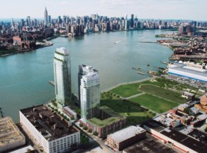
As for the architecture, OK, meh. For me, BIG’s whole schtick is about, well, big ideas with no nuance. The massing here is fine – yeah, the towers are ginormous, but any reduction in FAR will quickly knock off a lot of those small floor plates. Cut back the FAR 10% and I bet the height drops by 25% or more. I‘ve never been an opponent of height on its own. Everything on the waterfront is out of context with the neighborhood, but the overall urban design here is so much better than the 2005 paradigm.

The buildings from the 2005 rezoning – 40 stories with large floor plates on blocks that 400’ deep to the river set in semi-private compounds – are more offensive in terms of urban design than what is proposed here. Take a walk down South 1st from Kent and compare that to a walk down North 5th from Kent. The Battery Park City model on which the 2005 rezoning was based is just not good urban design, especially on very deep blocks, and 1 South 1st is great proof that taller buildings on smaller floorplates are more pedestrian friendly.

On affordable housing, there should be more. 30% to 35% at an overall average 40% AMI. Maybe this is unrealistic with existing subsidies & inclusionary housing, but if the city, state and feds aren’t going to build affordable housing they should at least pay others to do so. (Keeping this site zoned M3 means no affordable housing at all. 200+ units won’t be built under an M3 (or M-anything) scenario.)

And please, change the name.

“The Greenpoint” Developer Offers India Street Elevated Walkway for Flooded Ferry Entrance

What happens if you rezone a neighborhood for thousands of new residents, but don’t bother to plan any infrastructure around it?

As I understand it, India Street’s catch basins don’t tie into the City’s sewer system, they never have. And the City doesn’t have plans for these hookups for a number of years out. So people who wanted to get to the India Street Pier (and the ferry) were facing years of having to parkour over the plastic barriers to get to the pier. But now the developer of the “The Greenpoint” condominium is addressing the access to India Street via a temporary raised sidewalk while (as they should, even though the lack of infrastructure isn’t their doing this is literally their front yard).

How NYC’s Decade of Rezoning Changed the City of Industry

Eli Rosenberg, with a long, and very smart look at exactly why the Bushwick Inlet IBZ (and others) are broken:

But the massive redevelopment of the Williamsburg and Greenpoint waterfronts and the sudden desirability of the area was having a trickle down effect on even the IBZ, a small wedge in the middle of the vast rezoning that had transformed the two formerly industrial neighborhoods. A night market and concert venue had replaced the bakery across the street, with the leasing agents pitching the “central location and existing, vibrant night life scene.” A restaurant with a $125 dollar tasting menu had opened inside the IBZ a few blocks away. And the Wythe Hotel opened in Spring 2012 on the edge of the zone, quickly becoming a “summertime Eden” for a fresh crowd of jetsetters—a beneficiary of the nearly 200 blocks of rezoning the city pushed through in 2005, turning Williamsburg from an industrial neighborhood into a development free-for-all, as gleaming condo towers rose along a waterfront once blanketed by factories.

(A small point – people like to make a big deal about the Bloomberg administration’s 124 rezoning (“nearly 40% of the city’s acreage”), but they forget that many of those rezonings were contextual in nature, and did significantly change allowed uses or increase in any meaningful way the allowable density of development.)

Post-Sandy Rezoning at CB1

The agenda for Community Board 1’s Land Use Committee meeting tonight is a pretty sleepy affair – two BSA applications, both of which are retreads that the Board has heard in years past. However, there is one very important agenda item, which is a presentation by City Planning on the City’s proposed Flood Resilience Zoning Text Amendment, which modifies the zoning to allow new development to meet the new flood zone requirements.

I saw the presentation last week at CB2, and what the city is proposing is to modify the zoning to allow flood-resilient design with no (or minimal) impact on development rights. For those of you hoping that Sandy and the new FEMA flood zones will make development in Zone A impossible, this makes development possible. Actually, post-Sandy regulations don’t make development in Zone A impossible in the first place, in simple terms, they only restrict development and use at the base of buildings. These changes to the zoning will, in some case, permit taller development to compensate for the fact that ground floors now need to be flood-proofed in some manner and will no longer be usable floor area. Other modifications include not counting construction below the flood level as floor area and allowing greater amounts of rooftop mechanical area.

When: Tonight (June 25), 6:30 pm
Where: CB1 offices, 435 Graham Avenue

Bushwick Mall

Bushwick Daily has pictures from a Massey Knakal brochure marketing a proposed “Bushwick” Mall on Bogart Street in East Williamsburg. It’s not really clear if Massey Knakal is marketing the property (i.e., trying to entice someone to develop it) or if they are trying to market the project (i.e., someone is already planning to build this and is looking for tenants). Either way, this project seems to be more about the Bushwick Hotel than the Bushwick Mall.

Schizo Skyline

Stephen Jacob Smith is back, this time arguing that Two Trees’ Domino plan is somehow flawed because the upland zoning in Williamsburg is not dense enough. Where to begin – again?

But despite the best efforts of SHoP and Two Trees, the plan does not succeed in aping the natural parabolic shape of an organic thicket of towers found in midtown, downtown or even downtown Brooklyn. Nor could it—Williamsburg’s new planning regime, instituted in the 2005 rezoning and reinforced in 2009, makes sure of that…

A block or two away from the old Domino refinery, the skyline plummets to near zero—most sites across the street are zoned exclusively for industrial use, and cannot be developed beyond one and two stories. There is no gradual downward gradient.

Because the 2010 Domino zoning was a spot zoning – a really large one, but still spot zoning. When originally proposed in 2006 or so, the Domino rezoning actually included most of the surrounding industrial blocks. This made sense since the only reason those blocks were left out of the 2005 rezoning was because at that time Domino was still operational and had no plans to cease being so. Why did CPCR and the City take those blocks out – I have no idea, but it certainly wasn’t because of local “anti-growth” attitudes.

A block away, however, Mr. Smith’s dreamland actually does exist. East of Wythe Avenue, the Southside is zoned for medium to high density, largely without height limits. Because this area does have a lot of larger 6-story new-law tenements, it was not part of the 2009 contextual rezoning. This same context – R6 zoning with no height limits – also exists out along the L train in Bushwick. But not in between:

High-density building is allowed more than half a mile from the Bedford Avenue L, on the waterfront, but no housing is allowed at all on the blocks immediately adjacent to the Morgan Avenue stop. And it’s the pre-war neighborhoods, which sprouted naturally closest to the L, where residential development was most restricted in the rezonings.

OK – first of all, development did not sprout “naturally” along the L train. The L train was constructed as the Canarsie Line in the mid 1920s – well after 90% of the surrounding development, particularly that in the Northside, was constructed. The L train was a late addition, meant in part to connect the existing working class and industrial neighborhoods of Brooklyn to one another (and to Manhattan). One of those industrial neighborhoods was near the Morgan stop. That area is zoned industrial because it is a historically industrial area directly adjacent the canals of Newtown Creek and the LIRR freight spur. Maybe that zoning is outdated (I don’t think so, though I do think many other industrial areas are), but singling out one subway stop when the five stops before and the five stops after are in largely residential zones (some without those pernicious height limits) seems like cherry picking.

Northside

Looking at the photo to the right, you might be forgiven for thinking Smith has a point. But contrary to what the caption says “density differentials” are not that “par for the course on the waterfront.” The photo itself isn’t even real – it is clearly a rendering (by Toll Brothers, I assume) showing the full build out out of Northside Piers (the tower at left is just now under construction). To the north of Northside Piers is the Edge (3/4 of which is built out) and beyond that a park (because when you rezone a neighborhood for a population increase of 30,000, it helps to add some open space). And to the north of that is some low-scale industrial stuff that is also slated to become a park (that’s another story). Meanwhile, across Kent Avenue, most of the low-scale blocks shown in this rendering have been redeveloped or are in the process of being redeveloped, for 6- to 7-story residential. Even the hulking block-long building to the south of Northside Piers has been redeveloped – it now houses 242 residential units. All told, there are well over 1,000 new housing within two blocks of Northside Piers that are not shown in this image, and the density (not height) differential between the buildings on one side of Kent and those on the other is not really that dramatic.

This trope that low-scale neighborhoods are de facto low density is getting really tired, and no matter how many times Smith says it, it doesn’t make it true. As I pointed out the last time Smith raised this idea, there are actually a lot of unused development rights within the existing zoning for Williamsburg and East Williamsburg. A quick back-of-envelope calculation shows that much of the area is built to about two-thirds or three-quarters of its allowable floor area. And that’s just the existing housing stock – the two to (usually) three or four story vinyl-clad houses Smith abhors (but which, interestingly, people are willing to pay dearly for, and use as is, even when they are underbuilt by 50% – stupid market).

And this doesn’t begin to take account of the thousands of housing units at “projected development sites” identified in the 2005 rezoning that remain unbuilt. So even without rezoning for increased density, there is a lot more density to come. And capacity for plenty more built into the system.

Airbnb Advocates for Dwelling law Amendments

New York’s multiple dwelling law, which serves to make short-term rentals in large buildings illegal, was tightened in 2011 to curb the spread of illegal hotels in the city. Instead, it’s led to users of Airbnb being slapped with violations by city authorities for hosting strangers in their homes for short periods.

Interesting use of the word “instead”.

North Brooklyn Start-Ups Find Office Space Is Scarce

Though there are plenty of start-ups that favor Williamsburg and Greenpoint, developers, local officials and real estate brokers say there is a dearth of office space. Most landlords, lured by the promise of building lucrative apartments in the increasingly popular residential area, are reluctant to devote space to commercial tenants who can pay little and might wither as quickly as they bloom.

“Industry” in Brooklyn is booming, it is just not the smokestack-type industry that we all associate with Brooklyn. Whether start-ups, artisanal manufacturing, food processing, or film production, there is a huge demand for “manufacturing” space in North Brooklyn. And a huge need – the more jobs that can be made local, the less demand there is on our transportation infrastructure.

Although many buildings have retail space on the first floor, upper-floor offices are hard to come by, according to several people who have recently looked… Part of the problem is zoning: though parts of Williamsburg and Greenpoint are zoned for mixed commercial and residential use, the zoning tilts residential.

Ironically, this was among the objections raised in the community response to the 2005 rezoning – in converting hundreds of blocks of outdated industrial zoning to largely residential use, the city was turning a mixed-use community into a bedroom community.

Atlantic’s Credibility Crisis

Wow – Atlantic Cities let someone with no clue about development in Brooklyn write about development in Brooklyn. The basic premise of the article is that zoning (both use and FAR limits) is making housing more expensive by restricting the amount of new housing that can be constructed. In other words, the classic libertarian argument about land-use restrictions.

Let’s review:

According to data from the U.S. Census Bureau, the number of housing units in the five boroughs inched up an average of 0.5 percent annually between 2000 and 2010. That’s not even enough to keep pace with average U.S. population growth, which is about 1 percent per year.

The 2010 Census is so flawed, particularly with regard to Williamsburg and Greenpoint, that no credible argument can be based on its data. Remember, according to the census, much of North Brooklyn did not see a population increase between 2000 and 2010. Despite the very gentrification that Smith writes about, despite a building boom that has added thousands of new housing units since 2002 and despite a massive rezoning halfway through the decade that allowed for the creation of thousands more new housing units in formerly industrially-zoned areas. In all, something on the order of 4,000 new dwelling units (very conservatively estimated) have been added to the western parts of Greenpoint and Williamsburg since 2005 (the areas within and immediately adjacent to the 2005 rezoning). Hundreds if not thousands more have been added elsewhere in Greenpoint, Bushwick and the Southside.

Functionally, the industrial zoning along the waterfront and throughout Bushwick is hopelessly out of date. Urban manufacturing here is a shell of its former self. Car repair shops, wholesalers, warehouses and storage facilities are now the main tenants of Brooklyn’s “manfacturing core.”

What industrial zoning along the waterfront? 80% of the Williamsburg/Greenpoint waterfront was rezoned for residential use 7 years ago, and another 10% (Domino) in 2010. Hundreds of new housing units have been created on the Williamsburg waterfront, and hundreds more are coming to Greenpoint. There are three blocks of the Williamsburg waterfront that are still zoned manufacturing (between Grand and North 3rd) one of those blocks contains a power plant), and the other two.

Meanwhile, the remaining industrially-zoned areas of north Brooklyn are creating a lot of jobs. Good jobs, too. Look at the Brooklyn Navy Yard, a center of high-tech manufacturing and film production. Look at GMDC, which has a waiting list of small manufacturers. Look at the booming film production industry in Greenpoint. Historically, many people in north Brooklyn worked in north Brooklyn – not in Manhattan.

East Williamsburg actually has an abundance of underused land around Bushwick Creek, but Mayor Bloomberg and Brooklyn borough president Marty Markowitz don’t want to allow any residential development in the neighborhood, in order “to preserve the city’s manufacturing base.”

Bushwick Creek is not in East Williamsburg. It is not even a creek anymore. It is an inlet on the East River that divides Williamsburg and Greenpoint. Yes, the city created a small industrial carve out around Bushwick Inlet in 2005, and no, that carve out probably doesn’t make any sense.

…northern Brooklyn is underdeveloped. The hip neighborhoods around the L train, the main vehicle of gentrification in Williamsburg and Bushwick, are less than half as dense as Brooklyn neighborhoods like Crown Heights and Bed-Stuy.

Perhaps true – hard to tell from a jpeg of a map with no data sources listed (perhaps its from the census?). Regardless, much of Williamsburg and Greenpoint is actually under built compared to the allowable zoning. The potential density for north Brooklyn at current FAR limits is well above the actual density (in fact, it is probably comparable to the density shown in the fuzzy jpeg map, which seems to show much of brownstone Brooklyn at higher density than north Brooklyn – though all these areas have roughly the same zoned density).

Aesthetically, the vinyl-covered two- to four-story houses that dominate are some of the ugliest in the city. They lack the ornate cornices of their peers in south Brooklyn, and the brick patterns hidden behind the vinyl and stucco are plain compared to other pre-war styles.

So tear them down and we can build to a higher density. Zoning isn’t stopping that, and in fact that’s what is happening already (and has been happening very actively for a decade now). (And by the way, the brick is plain because a lot of those houses are pre-a-different-war – the Civil War; Williamsburg in particular has some of the oldest housing stock in the city.)

Problem is, from an infrastructure point of view, north Brooklyn is hurting. Unlike other areas of Brooklyn with higher population densities, north Brooklyn is not as richly served by public transit (if you pay attention to the map, the areas of highest density are along the public transit corridors), and it does not have as much park and open space as a lot of other areas. L trains run at capacity (in part because more newer residents are more likely to work in Manhattan, not locally), JMZ trains are rapidly gaining capacity (and neither line can be readily expanded), new bus lines, bike lanes and ferries are being added (but that only helps at the margins), parks and open space are overcrowded and over-utilized, and on and on. Sure, we could double the zoning density of North Brooklyn, but our infrastructure can’t even handle the thousands of people who have been added to the area to date, let alone the thousands more that will be added if currently as of right development continues apace.