
South Bushwick Reformed Church – RIP
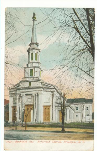
Sad news – a fire ripped through South Bushwick Reformed Church yesterday. From all reports, the building – constructed in 1853 and a NYC Landmark – is a total loss.
Sad news – a fire ripped through South Bushwick Reformed Church yesterday. From all reports, the building – constructed in 1853 and a NYC Landmark – is a total loss.
Twelve years ago, writing about Bill de Blasio’s inauguration, I said that he had an opportunity to build on the biggest accomplishment of the Bloomberg years, by taking the well-run city that he was inheriting from Mike and adding much-needed equity and fairness to the civic realm. I truly thought that de Blasio (who holds a graduate degree from Columbia’s School of International and Public Affairs) would embrace the task of running the city.
I was wrong.
Bill, in retrospect, had little interest in the wonkery of running a city. He hired good people, but constantly got in their way. Mostly, he did not seem to enjoy the role of executive.
Twelve years on, I am optimistic that Zohran actually wants to *run* a city. He has a love of New York. He has consistently surrounded himself with other wonks who love NYC. His early appointments back me up in that hope, the latest being (not that) Michael Flynn as DOT Commissioner and Ahmed Tigani as DOB Commissioner. He has appointed some progressives, but mostly he has appointed people of competence and experience (unlike, say Adams’s first DOB commissioner). My hope is that having appointed people of ability he gives them room to run their agencies without micromanaging and political interference (a good management lesson from Bloomberg). That would be a welcome change from the MO of the past two mayors.
Yes, the city that Mamdani is inheriting is very different than the one de Blasio inherited. De Blasio had the wind at his back – the city had been well run by technocrats for 12 years and the US economy was coming out of a deep recession. Mamdani on the other hand is facing the headwinds of 12 years of civic neglect, not to mention a hostile federal government.
Here’s hoping that he can overcome all of that and make NY thrive for all.
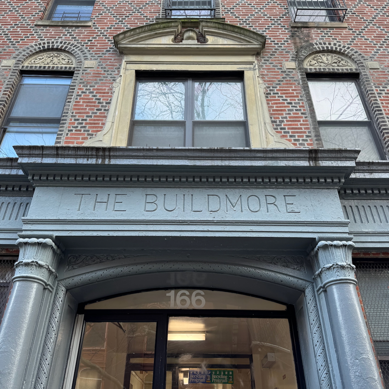
166 South 9th Street, Williamsburg.
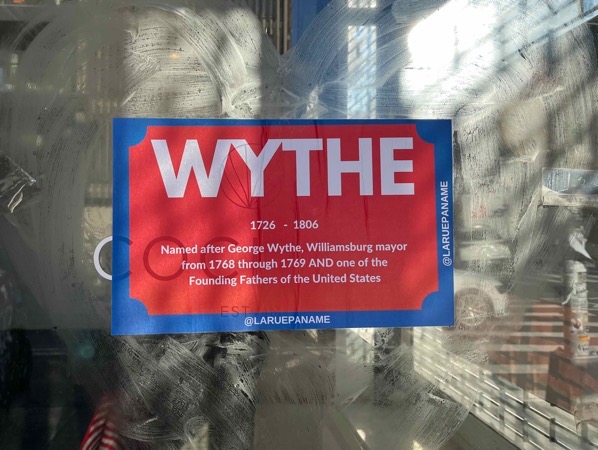
Love this guerrilla signage by @laruepaname, but George Wythe was mayor of Williamsburg, VIRGINIA in 1768-69. That he has street named for him in Williamsburg, Brooklyn is a complete coincidence.
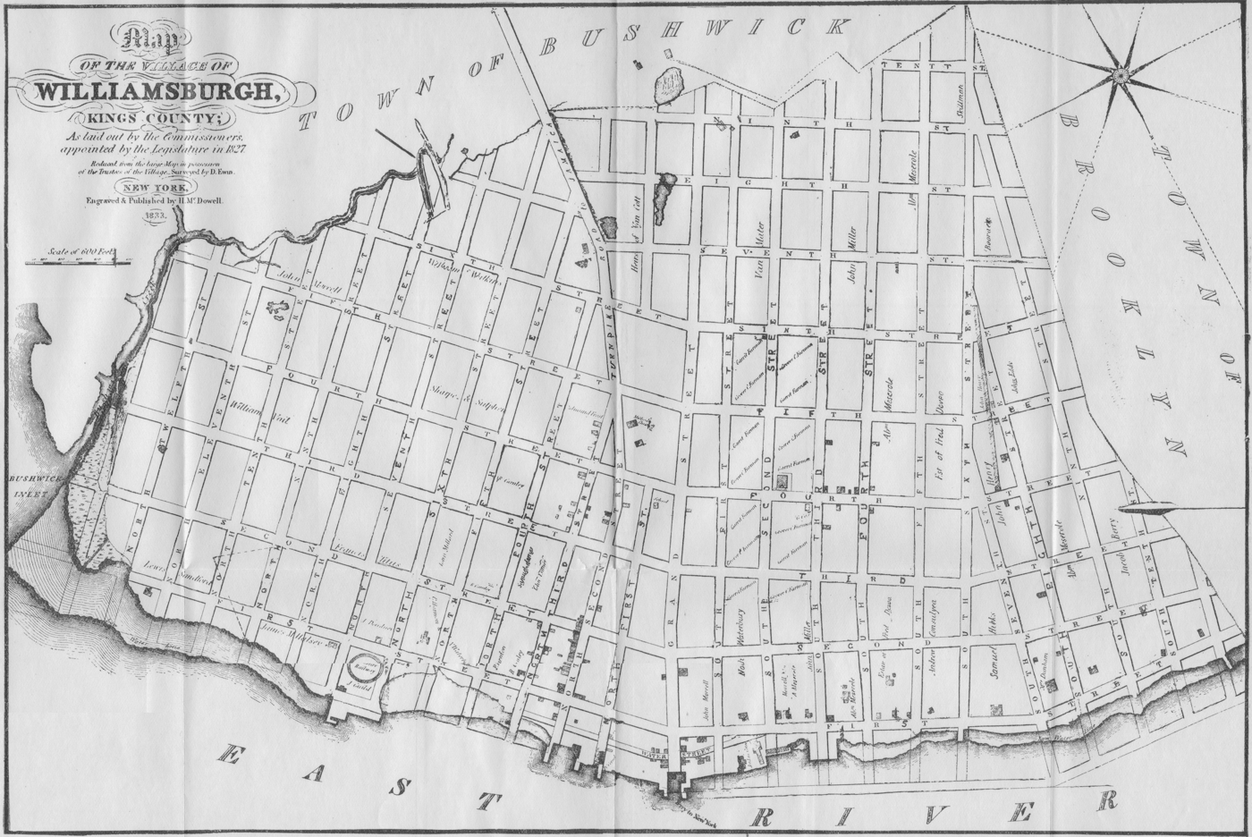
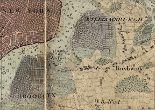
Williamsburgh (with an h), New York did not exist until 1802, which was when Richard Woodhull had surveyor Jonathan Williams lay out a street grid on the Bushwick waterfront. By 1828, Williamsburgh was a village, occupying the area between Division Avenue and Bushwick Inlet. In 1855 the then City of Williamsburgh became part of the City of Brooklyn.
The area between Division Avenue/Broadway and Flushing Avenue – in what is now South Williamsburg/Broadway Triangle – was the hinterlands of the City of Brooklyn. Called East Brooklyn, it was not laid out with streets until the mid-1840s. The city chose to name the streets after American patriots, with East Brooklyn getting the signers of the Declaration of Independence.
(The area south of Flushing out to Broadway, now Bed-Stuy, got some Signers as well as heroes of the Revolution and War of 1812 for their street names – Lafayette, Greene, Kosciusko, Decatur, etc.)
One of those signers was George Wythe, a delegate from Virginia and, yes, once mayor of Williamsburg, Virginia (more than 40 years before Williamsburgh, NY even existed on paper). As originally laid out, Wythe Avenue ran from Flushing to Division Avenue. Other avenues named for Signers were Chase (now Kent), Lee and Harrison.
The cross streets in East Brooklyn were also named for Signers – Thornton, Whipple, Bartlett, Gerry, Paine (now Wallabout), Walton, Gwinnet (now Lorimer), Middleton, Lynch, Heyward, Rutledge, Penn, Hewes, Hooper, Keap (sic, McKean), Rodney, Ross, Wilson, Taylor, Clymer, Morton, Rush and Morris.
(Side note – You won’t find the name Keap on the Declaration of Independence. William McKean, though, was a signer. Someone in Brooklyn misread his signature as William M. Keap, and the rest is history. And to be fair, the penmanship is pretty bad.)
The Street names of East Brooklyn did not continue into Williamsburgh – the north/south streets there were numbered from First Street at the river to Twelfth Street to the east. When the two cities combined in 1855, there were efforts to get rid of duplicate street names and make connections between the avenues of East Brooklyn and those of the Eastern District.
But that unification of street names did not fully come to pass until 1886, when the numbered avenues of Williamsburg finally took on the names of the East Brooklyn Avenues. First Street became Kent Avenue, Second Street Wythe Avenue, Fourth Street Bedford Avenue, and Eighth Street Marcy Avenue.
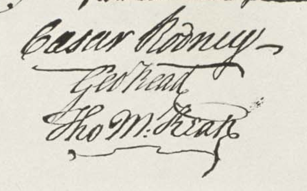
Because the grids of the two neighborhoods did not line up there is a jog or offset wherever a named avenue met a numbered street at Division Avenue. And because of the odd clashing of grids, other Williamsburgh north/south street took on the names of cross streets – so Ninth Street became Rodney Street, Tenth Street Keap Street, Eleventh Street Hooper Street and Twelfth Street Hewes Street.
The numbered streets in Williamsburg that dead-ended at Division Avenue took on the names of locals. Third Street and Fifth Street became Berry and Driggs, named for former Williamsburgh mayors; Sixth became Roebling (who had no Williamsburgh connections) and Seventh became Havemeyer (after the sugar family, one of whom was a mayor of Brooklyn).
So – while Berry and Driggs are named for mayors of Williamsburgh, George Wythe had no local connection. He was mayor of Williamsburg, Virginia 40 years before Williamsburgh, NY even existed. But Second Street in Williamsburgh, NY existed for 40+ before Wythe Avenue in Brooklyn ever came to be. And it was about 40 years after then that Wythe Avenue was extended into Williamsburg, Brooklyn.
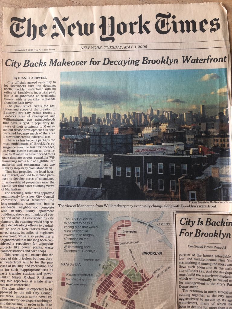
Via North Brooklyn Neighbors, the cover of the New York Times, 17 years ago today. Marking the finalization of the deal to rezone the Williamsburg/Greenpoint waterfront. The rezoning itself was enacted 8 days later. As I noted in an earlier linked post, 17 years on only a third of the promised Bushwick Inlet Park has been completed. Less than half the total open space promised has been created. And I’d guess a bit over half of the promised affordable housing.

In the papers…
via North Brooklyn Neighbors
For those that missed it, a week ago Tuesday (14 September) Community Board #1 voted to approve the Two Trees’ River Ring with a host of conditions. The discussion at the Board meeting was entirely about the merits of voting “no with conditions” (as the Land Use Committee recommended) or “yes with conditions”. There was no discussion about the conditions or even the project itself. For what it’s worth, my experience is that “no with conditions” gets a lot more attention from the public, press and elected officials. “No with conditions” means “we can’t approve this project unless these changes are made”; “yes with conditions” means “we generally like this project, except for these things”. But – and here’s the key – whether or not the conditions actually get acted on depends a lot more on the quality of the conditions and whether or not they are actionable, and a lot less on whether you are saying “yes, but…” or “no, but…”. Presumably BP Adams and CM Levin are looking to the Community Board for guidance, but they gave none – just a list of conditions with no discussion of why, no discussion of Board priorities (open space, affordable housing, YMCA – what’s important to keep?), nothing that actually helps the elected officials understand the CB’s thinking.
I had seen the conditions put forth by the Committee at the September 7th meeting and assumed that these would be incorporated into an actual resolution that discussed the merits and drawbacks of the project. I figured it would be unfair to comment on just the conditions without the full committee resolution to put them into context. But the report (read it here – it was not a resolution) from the Land Use Committee was really just an airing of grievances followed by the list of demands. No discussion of which aspects of the project the Committee liked, what they didn’t like, and most significantly – why.
So, what about the conditions? Here’s my take:
Condition #1: Two Trees must rent all affordable housing units in their 1 South 1st Street development to honor prior community affordable housing commitments.
Two Trees should do this, but more importantly they also should just explain (clearly) what the hold up is. As I understand it from this article and others, this is a dispute between various housing agencies and Two Trees regarding AMIs, rent stabilization and other issues, but it isn’t about TT reneging on its commitment to build affordable housing. But it doesn’t help TT (or people who need affordable housing) to have these units vacant.
Condition #2: Reduce total number of apartment units in the project by 33%, to reduce the anticipated increased load on existing overcapacity on subway transit, vehicular traffic, pedestrian traffic, wastewater and with street sanitation storage and collection, and open space.
Absent any discussion or analysis, this number is incredibly arbitrary. I’ve already said that the density should be reduced to match the high-rise density on adjacent waterfront sites. This is a smaller site than Northside Piers, the Edge and all of the Greenpoint waterfront developments, so a blended FAR doesn’t make any sense. By the same token neither does a one-third reduction (which would be less density than on the surrounding blocks). Knocking out 300 units of housing doesn’t solve any of the problems it purports to, and probably makes the whole project unviable. It certainly would make a lot of the really nice things about the project (open space, affordable housing, the YMCA, small-scale retail, etc.) unviable.
Condition #3: Increase the number of total affordable units to 50% to support deeper diversity and affordable living in the neighborhood.
I’ve already said that this should happen – didn’t attach a number because this is not my expertise. 50% is a worthy goal, though probably unachievable without a substantial increase in government subsidies. I would be very interested in seeing an analysis of what an achievable level of affordability on a larger project of this type is. In other words, the developer cross subsidy should account for X%, tax abatement should account for Y% and direct government subsidies should top out the Z% – does that reasonable add up to 35%? 40%? 50%? The CB resolution doesn’t provide any rationale for seeking 50% – it also doesn’t take a stance at all on the levels of affordability, which seems really weird. Would the CB be OK with 50% affordable at 130% of AMI? That meets the letter of their condition.
Condition #4: 60% of affordable units must be 2 & 3-bedroom units to encourage long term family occupancy.
Family-sized units are always in short supply, but I think that this condition could only be met if 60% of ALL of the units in the development were 2 and 3-bedroom units. MIH requires that the developer provide the same mix of affordable and market-rate units. For better or worse, the market determines the unit-size mix of affordable units. (It is also not clear that studios and one-bedrooms don’t also provide long-term occupancy – again, what is the problem that the CB is trying to address here?)
Condition #5: Within all affordable units one bedroom must be a minimum of 128 square feet to comfortably accommodate bedroom furniture, a closet and efficient movement throughout the room.
Sounds good, but not sure what the issue is here (again, an actual Committee resolution laying out the issues would really help). Are apartment bedrooms in general too small? Is this an issue with affordable housing units? Why 128 sf?
There aren’t a ton of rentals in the waterfront towers (all condos), but seems as though most listings, especially the two bedrooms, do have at least one bedroom that is larger than 128 sf. Example here from 1N1 – but based on a broader perusal of listing, 125 sf seem to be about the minimum. Again, what is the issue you are trying to fix here?.
Condition #6: The City of New York must include funding for the full completion of Bushwick Inlet Park in their 10-year capital plan so the fully operational park can help mitigate the existing severe local open space deficiencies that will persist if this project is built out and the massive population increase from the quantity of current and future local waterfront housing developments.
100%. The City should have funded this 16 years ago. If the City wants to see projects like River Ring – not even this project, but projects like it that provide affordable housing – the City need to live up to their promises and build the parks and other community benefits that they promised to. The fact that we are still advocating just to have the City do what it promised to do in 2004 is just a damning indictment of “planning”. Sadly, this is not something that Two Trees has much control over. Perhaps some leverage, which they should exert.
Condition #7: The project must use a fossil-free energy source such as a geothermal heat loop system instead of a natural gas reliant system for heating, which will work to have the project more aggressively meet the challenging but critical goals of the New York City Climate Protection Act, Climate Leadership and Community Protection Act and those set by the Intergovernmental Panel on Climate Change.
Also 100%. The project is already miles ahead of any other private development on the waterfront in terms of forward-thinking resiliency, energy efficiency, reducing carbon footprint, etc. (something that the CB resolution makes no mention of). Geothermal heating/cooling is not a new technology (I first saw it in 2000 on a project in Tribeca) – I’m sure there are scale issues on a project of this size, but if any developer has the money and will to make this happen, it is this one.
Condition #8: Redesign the towers so that they are significantly less obtrusive and oppressive in feel and fit more contextually with nearby structures and better connect with the historic fabric of the neighborhood.
What does this even mean? The context for this site is every other waterfront development, which is 40+ stories. I’m on record not being terribly concerned about height. For me, a well-designed 60-story building is far better than a generic 40-story building. And most of our waterfront is generic 40-story buildings modeled after Battery Park City – a 50-year-old paradigm! (which is most of our waterfront). Full-block developments that cut off the community from the waterfront and make crossing the street feel like you are entering into private enclave is not good urban design. 40’ waterfront esplanades with 10’ “buffer zones” in front of someone’s condo unit is not good urban design. None of this is contextual, stop trying to close the barn door. Sure, reduce the density and let the height follow, but cutting height for height’s sake (or because it is not “contextual”) is silly.
(I’m also already on the record as being underwhelmed by the architecture proposed for this development. I would love something better and more refined. But – the renderings are not determinative. The rezoning is to approve height, massing, open space, affordable housing and a lot of other things – but NOT design. TT could get an approval and change the design (or the architect) a week later. This is not a bad thing – they have done this to very good effect at Domino.)
Condition #9: Two Trees must negotiate in good faith with the New York City & Vicinity District Council of Carpenters to ensure the project adheres to the safest and best construction work practices.
I thought the unions were already on board? They testified in support of this project at both public meetings.
Condition #10: Two Trees must negotiate in good faith with local workforce organizations in order to provide service jobs for local job seekers.
Yes, another 100%. Pretty sure this was done at Domino.
Condition #11: Two Trees must provide funding in perpetuity for a local, independent agency or organization to oversee and enforce the rental fees and increases of affordable and market-rate apartments.
What does this mean? “Rental fees”? Does that mean rents? The rents at the affordable housing units are already heavily regulated, and under the new 421-a regulations the market rate units are part of the rent stabilization program. Who does the CB think should add onto these layers of regulation?
Condition #12: Two Trees and the City of New York must present and execute a plan to manage the steadily increasing volume of street trash that has come with the incredible volume of additional area residents that the project will exacerbate.
As a neighbor, this is a big quality of life issue. It is much worse along 184 Kent, Northside Piers, the Edge and MPJ/Bushwick Inlet Parks than further south, but nowhere is clean. The City in general and especially in the past year or two has just given up on sanitation, IMO (Ida was bad, but could have mitigated a bit if every storm sewer wasn’t full of trash). I hate to say it, but we need a BID –every development (condo board and developers) should be paying into trash pickup from Broadway to North 10th and the river to Wythe Avenue. The City has clearly just given up – at least until the next administration.
Condition #13: Before being granted any rezoning, Two Trees must present community facility architectural design plans which verify that the YMCA facility will serve the stated purpose and promise of serving both the Williamsburg and Greenpoint communities as well as 250 school children annually; it must show that the size and location of the facility elements including pool, locker rooms, saunas, facility/pool access including elevator, pool depth and lane width, lifeguard station, staging area and pool equipment, weight rooms, full gym arena, and exercise rooms are adequate as a full service facility for the communities. The community facility must be built out and in operation before the building can be occupied as a rental.
Sure, why not. The developer said at the public hearing that they had already developed test-fit plans. Make them public (not determinative (and not the Y’s plan), but something).
But what is the concern here? There is an underlying conspiracy theory (voiced by many neighbors) that the Y is just a big bait and switch. Somehow, TT is going to turn this YMCA into a tenant amenity for the oligarchs (and MIH residents) with no access for the public. Every community benefit/public amenity should be codified. But the way to do this is through the zoning (is the YMCA a required community facility space?) and through deed restrictions (X square footage of the space must be dedicated to a publicly-accessible physical culture facility in perpetuity).
If you don’t trust the developer to build the Y, demanding to see floorplans is a really ineffective way of holding them to account. Get it in the zoning, get it in the deed.
River Ring – the proposed rezoning by Two Trees of the former Con Ed site at Metropolitan and River Street – kicks off its ULURP review with a Community Board 1 Land Use committee meeting on Wednesday. Hopefully the CB recommends for changes but does not follow the lead of those who want to kill the project outright. This is a chance to rezone one of the last waterfront parcels on the East River, locking in a significant open space connector, affordable housing and more.
First off, this site should be residential. Period.
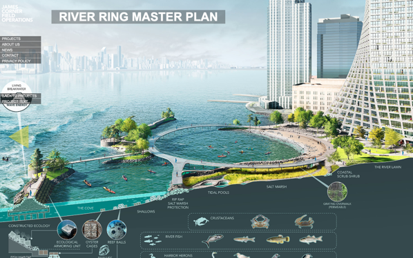
River Ring Master Plan
via FieldOps
There is no valid public policy reason to leave this zoned for heavy manufacturing. It should be smaller (floor area), which will make it shorter (not a big deal for me, but everyone else keys on the height). The open space is visionary and should be a model for future waterfront development – every developer should be held to this standard. It has everything community activists have been clamoring for and will connect the Southside waterfront and the rest of the neighborhood. There should be more affordable housing and it should be more affordable. 30% to 35% of the units, at a project-wide average AMI of 40%.
Hopefully CB1 supports the residential zoning *with* conditions. As they did for the 2010 Domino Rezoning (pre-Two Trees). In 2010 the CB did not say that residential use was inappropriate at Domino – rather that developer was trying to supersize the density. They should say the same thing here – support residential use, affordable housing and open space, but see it done better. (This would also be consistent with CB1’s District Needs statement, which lists affordable housing as the top TWO (of three) key issues for the community. It would also be in line with CB1 recommendations on other waterfront projects – Kedem Winery (420 Kent), Certified Lumber (Rose Plaza) and Shaefer Landing. Saying that this one parcel should be kept as M3 zoning doesn’t make sense in light of all these prior recommendations.)
There really is no valid public policy reason to leave the former Con Ed property zoned for M3 (heavy manufacturing). What kind of residential and how much can be debated, but if you are arguing to leave this as manufacturing you are not engaging in an honest debate. (The only other valid use I could see here is a public park. That would cost upwards of $300M for acquisition and construction – given the City’s track record at Bushwick Inlet, I’m not holding my breath. Not to mention that Parks would never build a build a waterfront park to the level of quality and design that Two Trees is proposing.)
This site should have been rezoned for residential years ago. In 2005 Domino was still in operation and it made sense to leave the area from Bway to N3 as manufacturing. But Domino closed shop just as that rezoning was going through, making the M zoning has been an anachronism. 11 years ago, when the first Domino Rezoning came through CB1, I asked why the City wasn’t developing a plan for the whole area – I still think that they should have. But instead, these parcels have been rezoned piecemeal – zoning, not planning, once again is the norm in NYC.
How much residential? I do think that the density being proposed is too much. Not a lot too much, but a bit too much. Back of the envelope, maybe 10% too much – the zoning should be straight R8, 6.5 FAR with the inclusionary bonus, same as the rest of the waterfront towers. (Yes, the waterfront sites from the 2005 Greenpoint-Williamsburg waterfront rezoning have a blended R6/R8 zoning, but on zoning lots that are 2 to 3 times the size of River St. and go all the way out to Kent/West. Blended zoning here would kill the affordable cross subsidy.)
Two Trees is also seeking a zoning waiver to reduce parking below what is required by zoning. Grant it. More parking means more cars, there is solid documentation for this. And more parking also means less affordable housing, there is solid documentation for that too.
In terms of the overall proposal, I love the waterfront access and open space. Field Ops design is truly transformative and is pretty much everything that open space advocates in the community have been asking for for years. It is resilient, both diurnally and annually. It is the first truly resilient open space on 4 miles of waterfront. It brings the public to the water without bulkheads, wharves or “get-downs”. It avoids the use of rip-rap and other unfriendly barriers between people and the water. The design reuses the pod wharves from the Con Ed site in creative ways to deal with the tides and currents of the East River. Most importantly, it CONNECTS the waterfront – the Northside esplanades to Grand Ferry Park, something that I and others have been advocating for years now. And it does so in a way that is a thousand times better than the waterfront esplanades of the 2005 rezoning. (Like at Domino, Two Trees promises to maintain the park rather than turning it over to Parks Department to manage – that is a very good thing too.)
(Also worth noting here for the proponents of leaving the M3 zoning intact – there is no requirement to provide waterfront access under the existing zoning – this property falls outside the Waterfront Access Plan, which requires public access to the waterfront. If an as-of-right development were to provide any waterfront access (and they don’t have to), it could be 100% private. No public access, not even an esplanade.)
As for the architecture, OK, meh. For me, BIG’s whole schtick is about, well, big ideas with no nuance. The massing here is fine – yeah, the towers are ginormous, but any reduction in FAR will quickly knock off a lot of those small floor plates. Cut back the FAR 10% and I bet the height drops by 25% or more. I‘ve never been an opponent of height on its own. Everything on the waterfront is out of context with the neighborhood, but the overall urban design here is so much better than the 2005 paradigm.
The buildings from the 2005 rezoning – 40 stories with large floor plates on blocks that 400’ deep to the river set in semi-private compounds – are more offensive in terms of urban design than what is proposed here. Take a walk down South 1st from Kent and compare that to a walk down North 5th from Kent. The Battery Park City model on which the 2005 rezoning was based is just not good urban design, especially on very deep blocks, and 1 South 1st is great proof that taller buildings on smaller floorplates are more pedestrian friendly.
On affordable housing, there should be more. 30% to 35% at an overall average 40% AMI. Maybe this is unrealistic with existing subsidies & inclusionary housing, but if the city, state and feds aren’t going to build affordable housing they should at least pay others to do so. (Keeping this site zoned M3 means no affordable housing at all. 200+ units won’t be built under an M3 (or M-anything) scenario.)
And please, change the name.
First Rough Trade moves to Rockefeller Center, now Samesa?
Is Rockefeller Center trying to become the new Williamsburg?
The North Brooklyn Open Space Coalition* held as excellent forum with the candidates for the District 33 and 34 City Council seats on Thursday. Some very good questions on parks, open space, development and the waterfront. Diana Reyna and Ron Shiffman did a great job moderating too.
Watch the forum via video link here (via Facebook – if there is a more open-source version out there, I will link to it).
* A coalition of North Brooklyn Neighbors, El Puente, Newtown Creek Alliance and North Brooklyn Parks Alliance. It is great to see these amazing groups working together.
July 4 is the 193rd anniversary of the end of slavery in New York. Prior to 1827 Kings County – then a collection of 6 towns (Brooklyn, Bushwick, Flatbush, Flatlands, New Utrecht and Gravesend) – had the largest number of enslaved persons in the state.
In 1698, Kings County had a population of 2,015, 293 of whom (15%) were enslaved. The Town of Bushwick (comprising today’s Bushwick, Williamsburg (north of Division) and Greenpoint) had a population of 301 in 1698, 52 of whom (17%) were enslaved.
In 1738, the Town of Bushwick had a population of 325, 77 of whom (24%) were Black. The 1738 census doesn’t enumerate enslaved persons, but it is reasonable to assume that all or nearly all of the 77 Blacks were not free.
A 1755 “census of slaves” for New York State counted 41 enslaved persons in Bushwick. Total population was not recorded, and the count appears not to be complete.
In the 1790 US census (the first for the new country), the Town of Bushwick had a total population of 540, 171 of whom (32%) we enslaved persons. 5 people were recorded as “other free” (i.,e., not “white” and not “slave”). Likely some of those were Black.
In 1800, the Town of Bushwick had a total population of 666, 199 of whom (30%) were enslaved persons. 34 people were counted under “All other free persons”, and by this time it is likely that some were Black. It is possible that up to 1/3 of Bushwick was Black in 1800.
In 1810, the Town of Bushwick had a population of 800, 147 of whom (18%) were enslaved persons. Another 59 persons were counted as “other free persons”. Based on this, up to 1/4 of Bushwick was Black in 1810.
Why the decrease in enslaved persons? NY state laws already limited slavery, and the owning of slaves was already being looked upon as a cruel relic. But, significantly for Bushwick the western part of Bushwick was being developed as a village – Williamsburgh – starting the transition from agrarian to urban. The population was tiny (100 or 200?) in 1810 but the establishment of the village was already removing acres of farmland.
This trend continues in 1820, when the population of the Town of Bushwick had grown to 1,072, of whole 120 (11%) were enslaved persons and 63 (6%) were “free colored”. About 2/3 of the free Black were counted as part of white households (some of which also included enslaved persons). There were only three families of free Blacks in 1820, headed by Thomas Thompson, Jack Portland and George Rictas.
In 1830, the Town of Bushwick had a population of 1,520, of whom 164 (11%) were Black (all free, following emancipation in 1827). 20% of the Black population was enumerated as part of a white household. But over 100 Blacks, in 27 households, lived independently.
By this time, the Village of Williamsburgh had been incorporated (also in 1827), accounting for almost all the growth in the Town’s population. The Black population of Williamsburgh was 97 (about 2/3 the Bushwick total), and 21 of the Black families lived in Williamsburgh, indicative of a sizable Black population (10% of the village total). Up to the Civil War, Williamsburgh had a sizable Black population, active in the abolitionist movement. But that’s another story…